Maphead: Charting the Wide, Weird World of Geography Wonks (35 page)
Read Maphead: Charting the Wide, Weird World of Geography Wonks Online
Authors: Ken Jennings
Tags: #General, #Social Science, #Technology & Engineering, #Reference, #Atlases, #Cartography, #Human Geography, #Atlases & Gazetteers, #Trivia

Geotags may sound like a small change—just a latitude and a longitude on a Facebook status, big deal!—but they have the potential to revolutionize the Web. The dominant online search paradigm now is one of a librarian: we suggest subjects using keywords (“Tell me about dinosaur fossils” or “Tell me about 401(k) plans”), and resources come off the shelves. But on the “geoweb,” data is indexed by place, not by theme, and so the search engine is a tour guide, not a librarian. You ask, “What’s around here?” (and that query is probably automated,
if you have a GPS-enabled phone), and the answers flood in: these friends, these businesses, these photos. In fact, the data is probably customized to the specific kinds of things you’ve decided you’re likely to be looking for: these geocaches, these clients, these Ethiopian restaurants. The Internet overlays itself on the real world like—well, like a map, frankly.
In 2005, a DreamWorks animation tool developer named Paul Rademacher was looking for a new place to live in the Bay Area. This being the primitive pre-geoweb era, he was apartment hunting with stone knives and bearskins: a new sheaf of MapQuest printouts every time he left the house. The programmer part of his brain knew that this was wrong. It was inelegant. Google Maps had launched two months previously, and Rademacher admired its smoothly scrolling maps. Wait a minute, he thought. This map is just JavaScript running in my browser, so therefore I can change it. Why can’t I just combine it with the list of for-rent apartments on Craigslist? Google Maps hadn’t yet released an API—application programming interface, a guide for users to interact with the software—so Rademacher proceeded by trial and error, tweaking numbers at random in the unintelligible text representing map layout, just to see what would happen. A few weeks later, he ran his script and watched a scatter of apartments appear in his browser, neatly forming the shape of the San Francisco peninsula. It was the first Google Earth “mashup” ever created, but within a month there were dozens of copycats using Rademacher’s code. Gas prices, movie showtimes, red-light cameras, package tracking, street crime—it seemed as if almost everything people wanted to look up on the Internet was a little more convenient displayed on a map.
“We all just hadn’t realized that a map could be a platform,” says Rademacher, who today works for Google Maps API team, managing the same interfaces he once hacked. Maps are millennia old, one of the earliest forms of representation ever devised by humankind, but new mobile technology has given them new versatility, and the result has been a map renaissance. Twenty years ago, most people probably consulted a map once every week or so, when they needed help navigating a highway or a shopping mall. Today it’s not unusual for smartphone
owners to check a map many times an hour, for things that we wouldn’t have associated with geography at all ten years ago—not just “Where’s Romania?” but “Where’s my pizza?” For geonerds, accustomed to the public perception of a map as something démodé and dull, it’s like living in a golden age.
Wayne Coyne, the lead singer of the beloved indie-rock band the Flaming Lips, may have summed this up best. In 2009, Google Street View
*
users noticed that the map photos of Coyne’s street in Oklahoma City included puzzling shots of the front man sitting, fully clothed, in a bathtub on his front lawn. He explained to an interviewer that he’d been trying out some props to scare neighborhood kids at a Halloween party and had no idea he was about to be immortalized by Google’s amazingly comprehensive street photography. “A car that drives around on every street with a 360-degree camera?” he marveled. “We live in f——ing good times, don’t we?”
But for every ebullient Wayne Coyne, it seems, there’s some gloomy Cassandra warning against the new maps and the technologies they leverage. If you thought the worst part of location-based services was going to be advertisements that annoy you by name as you walk past them, like in
Minority Report,
think again. Jerome Dobson, a GIS pioneer and president of the American Geographical Society, has coined the word “
geoslavery
” to refer to the potential threat to our privacy and autonomy that GPS-powered maps might someday pose. If everything you do is geotagged, then everyone always knows where you are—which is awesome if you’re hoping to meet some friends after work for a drink but maybe not so awesome if potential burglars are casing your neighborhood to find out who’s not home, or if you’re dealing with an abusive ex or a child predator or even some stranger who got mad about something you posted online. We’re an Orwellian
dystopia in the making, says Dobson, except that no shadowy government will be providing the surveillance. Instead, we’re opting to do it to ourselves.
With Google’s famous “Don’t be evil” motto in mind, I ask Paul Rademacher if he worries about the new digital map technology—call it Maps 2.0—turning evil. He tells me that Michael Jones, Google Earth’s chief technologist, often points out that
all
new technologies seem scary, but months later you find yourself wondering what you ever did without them. “He once gave the example of how cell phones now are cameras and how that seemed scary and invasive. You could just go in the bathroom and take pictures of everyone and put them on the Internet! But are we banning cell phones in bathrooms? I haven’t seen that happen, because people just leave their cell phones in their pockets.”
The example is telling. After all, no one actually
solved
the problem of camera-phone snooping; we’ve just decided to live with it because the advantages of camera phones outweigh, for now, the occasional abuses. If restroom spying ever turned into an epidemic, we’d look for legal or technological solutions—banning camera phones that can snap photos silently, for example. By the same token, abuse of location-based technologies could also be solved by smarter devices and better privacy settings. But those solutions work best in a free-market democracy. They’d be of little comfort if you were living in a North Korea–style dictatorship using this technology to keep tabs on every suspected dissident at every second or in a Taliban-style theocracy that wanted to keep college students in after dark or women out of movie theaters.
It goes without saying, of course, that Maps 2.0 has
saved
lives as well, from hikers stranded on mountainsides to Hurricane Katrina victims. In January 2010, a magnitude-seven earthquake flattened Port-au-Prince, the capital of Haiti. Rescue workers didn’t know where to start; even the ones with GPS receivers quickly discovered that there were no good digital maps of Haiti. Google, to its credit, gave the United Nations full access to the usually proprietary data in its collaborative Map Maker tool, but the real hero of the hour was the OpenStreetMap project, an open-source alternative to
Map Maker. OpenStreetMap is essentially the Wikipedia of maps: anyone can use it, anyone can change it in real time, and its data is free and uncopyrighted in perpetuity. When the earthquake struck, late Tuesday afternoon, Haiti was a white void in OpenStreetMap. Within hours,
thousands of amateur mappers
were collaborating all over the world, adding roads and buildings from aerial imagery to the database, until every back alley and footpath in Port-au-Prince had been charted. Relief workers updated the maps with traffic revisions, triage centers, and refugee centers, and just days later, the volunteer-drawn map was the United Nations’ go-to source of transportation information. “
Many thanks
to all crisis mappers for great contributions,” posted UNICEF emergency officer Jihad Abdalla. “You made my life much easier, since I’m a one-man show here . . . million thanks.”
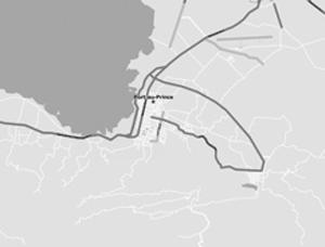

Port-au-Prince, as it looked in OpenStreetMap when the earthquake hit and the way it looked a week later
After reading about the lives saved in Haiti by OpenStreetMap, I used it to look at my own neighborhood and found that the cul-de-sac we live on was also missing from the map. After hesitating a moment—is it really okay to draw on a map?—I added and labeled my street by hand, Wikipedia-style. It was a surprising rush to add something new, however trivial, to the world’s sum of geographical knowledge.
*
For a brief moment, I was Captain Cook charting the New Zealand coastline, a veritable Stanley of the suburbs.
Most of these new technologies are just reinventing how maps are made or the things they can be used for, but one particular innovation is changing the very definition of what a map
is
. “Augmented reality” is the practice of combining a real-world environment with computer-generated imagery, like those yellow “first down” lines that appear and disappear during televised football games. Until recently, augmented reality was a mostly theoretical idea, confined to laboratories where, no doubt, people used those big, clunky
Lawnmower Man
helmets to try it out. But augmented reality isn’t virtual reality. The world it shows us isn’t a new one: it’s ours, only improved.
And in the age of GPS- and camera-enabled phones, you don’t need the helmet anymore. Imagine this: you walk out of a Manhattan office building and wonder where the closest subway is. Instead of consulting a bird’s-eye map, you just hold up your cell phone. The
screen shows your current point of view but augments it with a new layer of information: as you rotate the phone, symbols appear, hovering in the air in front of you as if fixed in place. There’s one for the Lexington Avenue Line, just 325 feet to your right. Maybe a dotted pink trail appears on the sidewalk to guide you directly to the nearest entrance, and you have to look twice to be sure the trail’s not there in real life. On the way, you notice that user reviews are fading into view when you point your phone at restaurants, and sightseeing links accompany tourist attractions. When you angle the camera upward, the windows of some of the apartments across the street have virtual
FOR RENT
signs with prices listed. This is all information you could glean from any number of digital maps, but there’s a crucial difference: for thousands of years, we mentally projected ourselves into maps; now map information has the ability to project itself
outward,
onto us.
I’m so accustomed to the endless disappointments of futurism (in a year that begins with a 2,
why am I not living in a domed undersea city by now?
) that it comes as a shock when I read that augmented-reality phone apps already exist—not in labs and at trade shows but for reals: free in Apple’s app store, even. I upgrade to a new iPhone just to try out some of these tools but wind up disappointed. One called Wikitude promises to embed my environment with information about nearby POIs, like a Web browser for the real world, but when I try it out in front of my house, all I see are logos for every Starbucks and Best Buy within five miles. Yelp’s augmented-reality Monocle, the first AR app available for the iPhone, is a little better, bringing up an accurate text box about my favorite Thai place when I hold the phone up vertically and point it northwest, but neither program provides a very compelling experience. My version of the Apple operating system doesn’t allow third parties to use incoming visual information, so these apps are trying to figure out what I’m looking at based solely on readings from the camera’s GPS device and accelerometer. Even if I make slow, smooth phone movements, the AR data wiggles and jerks around unpredictably, destroying any illusion that it’s painted over the real world. And a smart-phone screen is just too small and dim to be very immersive. You end up squinting and thinking for a minute and then saying, “Yeah, I guess that’s kind of cool,”
sort of like when you were looking at those Magic Eye posters of dolphins back in the 1990s.
But these are temporary glitches; before long, no doubt, the imagery will be smoother and we’ll all be wearing
Terminator
contact lenses with built-in heads-up displays for all the AR data. Not all the applications of augmented reality are map-related, of course. You could use it to interact with elaborate 3-D models that aren’t really there, which would be a boon to architects visualizing buildings and surgeons trying to practice a tricky triple bypass without killing anyone. If you were so inclined, you could even use AR to turn the world into your own surreal wonderland, changing the color of the sky every thirty seconds or putting a werewolf mask or Groucho glasses on the face of every passerby, like a Merry Pranksters app for an audience of one. But most day-to-day uses of the technology will probably be locational, and that makes me wonder: can this kind of in-world navigation even be called a map? It
is
a pictorial way to represent geography, I suppose, but one without any significant abstraction: the map is nothing but the territory itself with very good footnotes, a 3-D version of the
Sylvie and Bruno
map.