Read Hidden History: Lost Civilizations, Secret Knowledge, and Ancient Mysteries Online
Authors: Brian Haughton
Tags: #Fringe Science, #Gnostic Dementia, #U.S.A., #Alternative History, #Amazon.com, #Retail, #Archaeology, #History
Hidden History: Lost Civilizations, Secret Knowledge, and Ancient Mysteries (23 page)

Nazca Lines are located close to watercourses, and in many cases seem to follow the direction of the water. Perhaps
part of the function of the lines was to
point to sources of water?
An idea linked to the religious road
theory was proposed by English explorer and filmmaker Tony Morrison.
Morrison carried out extensive research into the ancient folkways of the
Nazca people and found a tradition of
wayside shrines, often merely a pile of
stones, linked together by straight
lines. Morrison believes that the Nazca
lines represent huge versions of these
folkways along which Shamans would
walk on a "voyage of the soul." Shamans
were members of a tribe who acted as
mediums between the visible world and
the invisible spirit world, and were
prominent in most Native American
societies. Perhaps when the Shamans
walked along the lines of the animal
glyphs, they were attempting to put
themselves in touch with potent animal spirits. On behalf of the tribe, the
Shaman would (in an altered state of
consciousness) make personal contact
with the supernatural powers contained within the glyphs and attempt
to utilize their energy, perhaps to bring
rainfall, or perhaps for a purpose we
could never even begin to understand.
The experience of Shamans usually involved some sort of flight, so Erich von
Daniken may in fact have been partly
right when he proposed that the glyphs
were designed to be seen from the air.
However, there is no need for alien visitors; the motivation for the creation of
the Nazca lines was connected with the
mountain spirits of the Nazcans high
up in the misty Andes, their gods dwelling in the sky, and the mystical flights
of their Shamans.

The Piri Reis
map, one of the oldest known surviving
maps showing the
Americas, first came
to light in 1929,
when historians
working in the
Topkapi Palace in
Istanbul discovered
it in a pile of rubble.
It is currently located in the Library
of the Topkapi Palace, though it is not
usually on display to
the public. The map
dates to the year
1513 and was drawn
on gazelle skin by an
admiral in the Ottoman Turkish fleet
named Piri Reis. It includes a web of
criss-crossing lines, known as rhumb
lines, common on late medieval
mariner's charts, and thought to have
been used in plotting out a course.
Close examination of the document
has shown that it was originally a map
of the whole world, but was torn into
pieces at some time in its history.
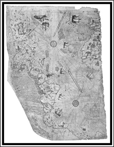
The Piri Reis Map.
The map itself is known as a
portolan chart, a type common in the
14th to 16th centuries. Such charts
were drawn up to guide navigators
from port to port,
but were not reliable
for sailing across an
ocean, as they did
not consider the
Earth's curvature.
Such an early map
showing America is
obviously of considerable historical interest, but some
would argue that its
importance lies not
merely in its depiction of the Americas. In his book
Maps of the Ancient
Sea Kings first published in 1966,
Charles Hapgood, a
historian and geographer at the University of New Hampshire, put forward the theory that the landmass
joined to the southern part of South
America at the bottom of the map can
only be a depiction of Antarctica, hundreds of years before it was discovered.
The apparently detailed rendering of
the Antarctic coastline on the chart,
including what Hapgood believed was
an accurate depiction of Queen Maud
Land, shows it without glaciers, which
would suggest the continent was
mapped in remote prehistory, before it became completely covered in ice. But
how was Stone Age man able to survey
and chart the region of Antarctica at
such an early period in human history?
Hapgood suggested the existence of
now forgotten prehistoric seafaring
civilizations, whose achievements included journeying from pole to pole
and mapping the entire surface of the
Earth at some time in the remote past.
Hapgood theorized that these civilizations left a legacy of maps, which were
hand copied over thousands of years,
perhaps by expert seafaring cultures
such as the Minoans and the Phoenicians. For Hapgood, the Piri Reis
map was, in effect, a compilation of
these ancient maps.
Later, the controversial author
Erich von Daniken considered the depiction of a pre-ice-covered Antarctica
on the Piri Reis map as evidence to
support his ancient astronaut theory,
speculating that an extraterrestrial
civilization had drawn the original
map. In his 1995 book Fingerprints of
the Gods, Graham Hancock also postulated that a previously unidentified,
highly advanced ancient civilization
existed in remote prehistory and
passed on its sophisticated knowledge
of astronomy, architecture, navigation,
and mathematics to various ancient
cultures including the Olmecs, Aztecs,
Maya, and Egyptians. He also speculated that the Piri Reis map-makers
may have used source maps compiled
by this ancient super-culture. Both
Hapgood and Hancock maintain that
the Antarctica represented on the Piri
Reis map is highly detailed, showing
mountains, rivers, and lakes, and that
it may have been based on ancient satellite surveys from the sky above Egypt.
Many scientists and archaeologists
are sceptical of Hapgood's theory in the
first place because there is no record
of such an ancient civilization that had
the resources, the technology, or most
especially the need to undertake a survey of Antarctica. What possible reason could they have had? Allowing for
the existence of this advanced prehistoric culture, does the Piri Reis map
convincingly show an Antarctica free
of ice? Most proponents of the ancient
mariner theory emphasize the accuracy of the map, especially the part
showing Antarctica, as evidence of lost
geographical knowledge. But how accurate is the Piri Reis map? The absence of the Drake Passage between
South America and Antarctica means
that if the map does show Antarctica,
then it depicts it joined to the South
American continent, with roughly 932
miles of coast from Brazil to Tierra del
Fuego left off. This would be a glaring
omission for such a supposedly accurate map.
Examining the rest of the chart,
Europe and Africa are shown in a reasonable amount of detail for the time,
though peninsulas and inlets are exaggerated, probably due to the necessity at the time of navigating by
landmarks. South America is represented as far too narrow although Brazil is fairly accurately shown. North
America, on the other hand, is poorly
drawn and enormously inaccurate, as
if based entirely on hearsay rather
than geographical knowledge, something else that would suggest there
was no ancient global survey on which
to base the map. In fact, there are earlier maps from around A.D. 1500, such
as those of Juan de La Cosa and Alberto
Cantino, which are more accurate than the Piri Reis map in terms of the positions of islands such as Cuba, Jamaica,
and Puerto Rico. One detail, which is
alleged to support the extreme antiquity of the map, is that it shows
Greenland before it was covered by ice.
However, as can be seen from a quick
perusal of the map, the top eastern
edge clearly shows the western part
of France, which is at about 50 degrees
north latitude. Consequently, if
France is represented as the most
northern country on the map, surely
Greenland cannot be depicted, and as
the map exhibits no islands which are
remotely similar to Greenland, it is
difficult to know what evidence there
is for this suggestion.
To support his theory that the Piri
Reis map depicted Antarctica under
the ice, Charles Hapgood used sounding data from Antarctic expeditions in
the 1940s and 1950s. But Hapgood's hypothesis, once thought by some as
scientifically plausible, is now in serious doubt. The insurmountable difficulty with a pre-ice-covered Antarctica
being shown on the Piri Reis map is
that when Antarctica was last free of
ice, its coastal outline would have
looked completely different than its
current shape. This is because over
time, the continental crust has been
forced down hundreds of meters, under millions of tons of ice, thus changing the shape of the underlying
shoreline completely. A comparison
between the Antarctica shown on the
Piri Reis map with a relatively recent
sub-glacial bedrock topography map of
the continent shows no similarities at
all between their coastlines. Furthermore, rather than Antarctica being
free of ice by 4000 B.c., as claimed by
Hapgood, modern geological evidence
now points to the most recent date for
an ice-free Antarctica as being more
than 14 million years ago.
But perhaps the most convincing
evidence against a prehistoric origin
for the chart can be found in the notes
written on it by Piri Reis himself. In
the early 16th century, when the Piri
Reis map was drawn, the Portuguese
had sailed across the Atlantic and
were claiming substantial parts of
South America as their own. In relation to the supposed Antarctica land
mass, the captions on the map mention
that its coast was discovered by Portuguese explorers, whose ships had
been blown off course. A particular
note on the map refers to a Portuguese
ship that landed on this coast and was
immediately attacked by unclothed natives; a further caption refers to very
hot weather. These descriptions could
clearly apply to South America, but hot
weather and naked inhabitants in Antarctica are clearly nothing more than
fantasy.
The sources for Piri Reis's map
have not all been identified by any
means, but would likely have included
the works of Greek astronomer and
geographer Ptolemy (second century
A.D.), various Portuguese maps, and
Christopher Columbus. In fact, Reis
himself notes on the chart that he copied from Columbus's maps. Many features on the Piri Reis map, including
place names and representations in
the West Indies, show that he was using at least one of Columbus's maps to
draw his own chart. Another indication that Reis was using medieval European maps is the depiction, near the
top of the chart, of a ship next to a fish,
which carries two people on its back. The note attached to this illustration
quotes a medieval story from the life
of the Irish saint, Brendan. This has
obviously been reproduced by Piri Reis
from one of his source maps, proving
that one of them, at least, was of medieval European origin.
Greg McIntosh in his The Piri Reis
Map of 1513, published in 2000, argues
that looking at contemporary maps of
the period shows that nothing in the
Piri Reis map was unknown in 1513.
He also suggests that what some have
called Antarctica on the Piri Reis map
is, in reality, the hypothetical Great
Southern Continent, which cartographers had been depicting on maps
since Ptolemy's time. The commonly
held belief was that a continent must
exist in the southern hemisphere to
balance the landmasses in the northern hemisphere. McIntosh also demonstrates that all the coasts on the Piri
Reis map south of 25 degrees are either inaccurate or wrongly placed, and
that the Antarctica depicted on Reis's
chart extends north of 40 degrees
south latitude, while the actual continent of Antarctica does not extend further than 70. In fact, rather than being
a depiction of Antarctica, a close examination of the Piri Reis map reveals
that the southern continent bears an
extremely close resemblance to the
southern half of South America, adjusted width-ways to fit onto the shape
of the parchment.
One conspicuously anomalous feature of South America on the Piri Reis
map is its apparent depiction of the
Andes mountain chain, with the rivers
Amazon, Orinoco, and Rio Plata
emerging from its base and flowing
eastwards to the coast. As the Andes
were unknown to Europeans at this
time, how did they come to be shown
on Piri Reis's map? But Reis's map is
not alone in showing a mountain range
in the interior of South America; the
Nicolo Canerio map, drawn between
1502 and 1504 and now housed in the
Bibliotheque Nationale in Paris, depicts the east coast of South America
with a tree-topped chain of mountains.
From this evidence, it seems likely
that the Canerio map was another of
Piri Reis's original sources. It is also
hard to conceive that if the Piri Reis
map were based on the work of an advanced ancient seafaring culture, it
would include the Andes but omit the
Pacific Ocean. A more plausible explanation is that the mountains depicted
in the center of South America on the
Piri Reis map are east coast mountains, drawn in the wrong place and
at the wrong scale.