Finding Arthur (17 page)
Authors: Adam Ardrey
Tags: #HIS000000; HIS015000; BIO014000; BIO000000; BIO006000

Head west, away from Loch Lomond, across the
Rest-and-be-thankful
road, you will find that the road falls steeply down towards Inveraray, the capital of Argyll. Beyond Inveraray a string of
Ard Airigh
place-names runs north–south down the spine of Arthur’s Dalriada; these include, among others, Ardery near Strontian in Sunart, where I met Jimmy Ardery; Dun Creagach, the fort south of Connel named Ardery on Timothy Pont’s sixteenth-century maps; Ardary and Aredrey on the banks of Loch Awe; and Dunardry at the southern end of the Kilmartin Glen.
In the sixth century the most important route in Argyll was the portage road that ran east–west along the line of the modern Crinan Canal, in the shadow of Dunardry. This made Dunardry the obvious administrative capital of Argyll. It is unlikely to be mere coincidence that at the very foot of Dunardry, exactly where one would expect business to be transacted, goods inspected, tolls levied, and travelers identified and given permission to pass, there is a place called
Tighean Leacainn
, the “smooth slope of the master or sovereign.” Tighean Leacainn
was probably, in effect, Argyll’s commercial district. This lends weight to the view that Dunardry and other
Airigh
-places do not have pasture but lordly connotations.
Contiguous with Tighean Leacainn is
Dhaill
, a place-name that can and usually does mean a portion or a share, as in the place-name Dalkeith, the portion or share of the Keiths. The
Dhaill
at the foot of Dunardry stands alone and does not have a name attached to it, and so, if it was ever meant to signify some particular party’s portion or share, that information has been lost. It is more likely however that this
Dhaill
at the foot of Dunardry, next to the smooth slope of the lords, where business was transacted and meetings were held, denotes a meeting place, a place of business and parley—literally a parliament, a place where people would meet to talk. (The name of the House of Representatives of the Parliament of the Republic of Ireland,
Dáil Éireann
, is from the same root.) Again, this suggests there was more to Dunardry than has hitherto been thought.
Airigh
is an element in many modern Gaelic place-names. Sometimes it means a summer pasture or shieling; sometimes it has O’Brien’s older meaning, lord. However, it would require someone more patient than me, with significant linguistic skills and some statistical ability, to work out which
Airigh
was which on each individual occasion. I suspect that even such a person would find it impossible to reach a definitive conclusion in every instance.
Not only do Q-Celtic
Ard Airigh
place-names speckle the heartland of Arthur Mac Aedan’s Q-Celtic speaking Dalriada, they can also be found in the P-Celtic speaking lands of the Britons: Arderydd where Arthur Mac Aedan fought against Merlin-Lailoken in 573; Ard Airigh, now Ardery Street, Partick, Glasgow, where, I have submitted in
Finding Merlin
, Merlin-Lailoken lived toward the end of his long life; the town of Airdrie (
Ardrytoun
or
Ardry
)
2
in central Scotland; and, two miles north of Airdrie, Arderyth. If Arthur was Arthur Mac Aedan it would not be surprising that the
Ard Airigh
names found in Arthur Mac Aedan’s Argyll also echo in the southlands of Manau, in Airdrie and Arderyth, where Arthur’s father Aedan ruled and Arthur Mac Aedan patrolled the border.
East of Dunardry-Dunadd, upriver along the Add and past the
village of Kilmichael Glassary is Glen Airigh, traditionally the Glen of the Pasture, but which, if O’Brien’s definition of
Airigh
is correct is really the Glen of the Lord or Lords. There is nothing particularly pasture-like about Glen Airigh. It is very much like many other Scottish glens. On the other hand it is where the kings of the Scots were based, from the time of Fergus (circa 500) until the middle of the ninth century when Viking pressure led the Scots to move their capital east to Scone, Perth. Is it not more likely that Glen Airigh, rather than being called by a “pasture” name, would have been given a name that something to do with a lord or with lords?
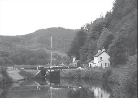
Dunardry hill, Dun Monaidh, Mount Badon, looking west along the Crinan Canal, Cairnbaan, Argyll
Located between Kilmichael Glassary and Glen Airigh is Lecknary, an obvious corruption of a Gaelic name.
Lecknary
is usually taken as a version of
Leac-nathrach
meaning “Flat Stone of the Serpent,”
nathair
being “serpent” in Gaelic. But what serpent? Why should this
stone, in this place, have anything to do with a serpent? Lecknary stands sentinel at the entrance to Glen Airigh, and so there is a more sensible interpretation of the name
Lecknary
.
Leac
means a “great stone” or a “flat stone”: that is, a stone upon which something might be carved. It may be that a Pictish sculptor carved a snake on a stone in this place and so inspired the name
Flat Stone of the Serpent
, but is it not more likely, given that Lecknary stands at the entry to Glen Airigh, where the sixth-century equivalent of a road sign might have stood, that it was originally
Leac na Airigh
—the great or flat stone of the Lord or Lords?
The River Add runs through Glen Airigh, past the 482 meters of the hill Airigh Ard, which, according to the conventional wisdom, means “hill of the high pasture” although, again, this is for no obvious geographical reason. By my account, it is the hill of the high lord or lords. North of Airigh Ard and south of Ben Dearg is the source of the river. Beyond Ben Dearg the hills slope away, down to the town of Inveraray, the ancient seat of the Dukes of Argyll.
The town signposts say that the name Inveraray is derived from the Gaelic,
Inbhir Aora. Inbhir
, pronounced
inver
, means “an inlet,” and
aora
means “rough water” (being derived from
aò-reidh
—literally, “not-smooth”). This interpretation says the reference to “rough water” is to two burns that run nearby, one of rough water and the other of smooth water, although it seemed to me when I read this explanation that even the writer did not find it convincing.
The Duke of Argyll’s onetime factor, Mr. P. M. Fairweather, kindly told me in an exchange of letters that, “One of the earliest written references to Inveraray is … found on Timothy Pont’s map circa 1590 on which there is a reference to the
Castel of Inreyra
.” I knew this. This
Inreyra
reference is an obvious misspelling, probably based on a mishearing. Whatever the last part of the name may be, the first part is undoubtedly
inver
, “inlet,” a word commonly used in place-names in the Gaelic speaking parts of Scotland, and one which describes the geography of Inveraray exactly. Mr. Fairweather went on to say, “[In] the Registrar of the Great Seal of Scotland there is an entry for 8th May 1474 referring to
Villam de Innowreyra
. In 1648 when King Charles I granted a Charter giving Royal Burgh status, the spelling appears to be
Inverarey
. (This was supported by a Valuation Roll entry of 1648 when the spelling is
Inverairey
.)”
Innowreyra
and
Inverairey
were new to me. I added them to a list that also included
Invedraray
, a name taken from a charter signed by a Duke of Argyll in 1669. The first of Mr. Fairweather’s versions,
Innowreyra
, was probably recorded by a clerk who was unfamiliar with his informant’s accent or perhaps even with his language, leading the clerk to write what he thought he had heard without checking that the end result was anywhere near right. The second version,
Inverairey
, was closer to what I had come to believe was the true source of the town-name,
Inbhir Airigh
, Inlet of the Lords. Inlet of the Lords makes sense. Inlet of the Rough Water does not make sense, well, not much sense: two burns, one smooth and one rough and they named the town after the rough one. How likely is that?
Given all the other
Airigh
place-names just over the hill to the south and the fact that in recent centuries Inveraray has been the main base of the lords of Argyll—indeed, even today the Duke of Argyll has his seat there—it is more likely that Inveraray is
Inbhir Airigh
and that it means the inlet of the lords. If this is so, the signposts that translate Inveraray as
Inbhir Aora
stand to be changed to
Inbhir Airigh
.
The name Arthur has been commemorated in the name of the Argyll clan of MacArthur, a name, it is said, that was “Ancient even in remote Celtic times.” It is also said, albeit mainly by MacArthurs, that “There is nothing older, except the hills, MacArthur, and the devil.” The MacArthurs fought for the hero king, Robert Bruce, in the Scottish War of Independence in the early fourteenth century and were rewarded with royal recognition of their titles to their lands. They were also awarded, as the spoils of war, lands taken from the Bruce’s defeated enemies the MacDougalls. The most powerful MacArthur house, the MacArthurs of Loch Awe, was given lands that included Dunstaffnage Castle outside Oban (once the resting place of the Stone of Destiny) and Ardery and Aredrey on Loch Awe. This was the high point in MacArthur fortunes. In the early fifteenth century James I, King of Scots, favored the Campbells at the expense of the MacArthurs. When James executed Iain MacArthur, the Clan Chief, MacArthur fortunes waned and never recovered.
The Campbells went on to become the most influential family in Argyll.
That the MacArthurs hail from Argyll suggests there was an Arthur whose name and fame lived on after his death, whoever he was. If the MacArthurs were named for Arthur Mac Aedan and if Arthur Mac Aedan was the man who inspired the legend of Arthur, it would be easy to see where both the name and the fame originated.
MacArthur is not the only clan to imagine a connection with the legendary Arthur. In a Gaelic manuscript dated 1467, Dubhghall Albanach mac mhic Cathail (Scottish Dugald, son of the son of Cathal), staked a Campbell claim to descent from the legendary Arthur.
3
The first part of the 1467 manuscript is a Campbell genealogy that puts the legendary Arthur firmly in Argyll: “Young Colin son of Archibald son of Colin son of Allan son of Neil son of big Allan son of Archibald son of Dugald son of Duncan son of Archibald son of Gille Coliam son of Duibhne son of Eirenan son of Smeirbhe son of Arthur son of Uther, that is, the unopposed king of the world.”
This was written a very long time after Arthur, and medieval records are notoriously unreliable, but one thing is clear—Scottish Dugald, or whoever provided him with his source material, thought to claim the legendary Arthur as an ascendant of one line of Clan Campbell of Argyll. While the reference to Uther makes the evidence of Scottish Dugald somewhat suspect, the fact remains that only clans in Argyll can make such claims.
Notwithstanding his Argyll connections, Arthur was not always a man of Argyll. He came there from the east, from Manau; indeed, there is reason to believe that to the people of Argyll Arthur was always an easterner really. The sixth century kingdom of Manau was centered on Stirling, which has been called “the brooch that holds Scotland together.” Manau lay north of Strathclyde, south of the lands of the Miathi Picts, east of Dalriada, and west of the lands of the Gododdin, and so was of vital strategic importance. Echoes of the name Manau can still be heard in the names of the modern towns Clackmannan, nine miles east of Stirling, and Slamannan, twenty miles south of Stirling. According to Skene, Manau’s western boundary was Slamannan, from which it extended east to the river Esk, although there is reason to
believe Skene set Manau’s western boundary too far to the east. This might be a moot point because in the 150 years between the departure of the Romans and the birth of Arthur, Manau’s borders fluctuated wildly.
Wherever the border was at any given time, the site of what is now the town of Airdrie was the most important strategic location between the kingdoms of Strathclyde and Manau. From Airdriehill it is possible to look across the Clyde Valley to the Firth of Clyde and beyond to western Argyll. Ben Arthur and Ben Lomond are visible to the north, as is Tinto Hill to the south: hills that were not only observation points but signal-fire hills that enabled whoever held them to communicate over long distances. To control the contested lands that lay between Strathclyde and Manau it was necessary to control Airdriehill.
So who controlled Airdriehill in the time of Arthur Mac Aedan? The answer to this question may lie in the very name, Airdrie. Blaeu’s 1654 maps
4
show Airdrie as Ardry. Peter Drummond in his
Place-names of the Monklands
calls it Ardrytoun. There is clearly some connection between Airdrie-Ardry-Ardrytoun and Dunardry, where Arthur Mac Aedan was active in 574. Airdrie is also on land that was ruled by Arthur Mac Aedan’s father in 574. It is therefore reasonable to suppose some connection between Arthur Mac Aedan and Airdrie. The alternative would be to suppose that Arthur Mac Aedan’s Dunardry association and Arthur Mac Aedan’s Airdrie association were purely coincidental. It is more likely that for some similar reason Dunardry was called the hillfort of the High Lords and that the signal-hill Airdriehill was called the place of the High Lords: that is, because they were both associated with Arthur Mac Aedan’s war-band, a war-band that was called something akin to the
Ard Airighaich
or the
Ard Airighean
, the High Lords. In effect, the High Lords of war.