Read Stonehenge a New Understanding Online
Authors: Mike Parker Pearson
Tags: #Social Science, #Archaeology
Stonehenge a New Understanding (14 page)

Model of Phase 2a of the Southern Circle. In this phase, a horseshoe-shaped arrangement of timber posts was erected inside three concentric circles.
Model of Phase 2b of the Southern Circle. In this last phase, a ring of posts was added at the center of the circle and a final ring was added around the outside.
I was keen to ask Geoff and other old-timers about the Durrington Walls excavation. Although I’d worked with Central Unit diggers before going to university, and had heard a lot of stories, I wanted to get a sober version of what happened during the ’67 dig. Geoff came to visit in 2004, taking the opportunity to re-visit the Stonehenge Inn (from which he had been barred thirty-seven years before). Two of his supervisors, Dave Buckley and Peter Drewett, both now senior archaeologists, also had stories to tell of the wild parties and the hectic digging. Living conditions were spartan. The campsite was in the excavation field, with just a single cold-water tap. Today it just wouldn’t be allowed—one portable john for every ten people is mandatory, for example, and students absolutely must be able to charge their mobile phones.
On site, the ’67 team worked hard and dealt with everything Geoff and the site threw at them. Many among the first swath of a dozen supervisors were not up to the job and only four survived to the end of the
season. Peter Drewett, then only nineteen, found himself in charge of most of the day-to-day digging and planning. Pedro Donaldson was another of Geoff’s hard-driving supervisors. Peter and Dave remembered a careless dumptruck once going straight over the edge of the ditch, to be caught by the mechanical arm of a fast-acting digger driver. The excavation finished with the burial of someone’s Ford Prefect in the henge ditch.
In August 2005 we had the chance to go back to the Southern Circle and answer questions that had been building up for years. We devised a strategy for excavating just enough of its remaining western arc for our needs, leaving as much as possible still untouched for archaeologists of the future. A narrow trench from the edge of the circle toward its center would provide a selection of postholes in each of the outer five rings. It was also important to get a full plan but the postholes were buried too deep for conventional geophysics and ground-penetrating radar to work. We therefore carefully removed the top meter of colluvium and carried out the geophysics from that height.
Julian Thomas directed the excavation and was delighted to find one antler pick after another in the postholes, crucial finds for radiocarbon dating. It was clear that the weathering cones were, as we suspected, later pits cut into the tops of the decayed posts. Some of these pits had taken centuries to fill up. Pieces of two human skulls from the fill of one pit dated to around 1800 BC, more than five hundred years later than the posts themselves.
Julian also discovered that the circle had a second entrance on its northwest side, formed by two large postholes within the outermost ring. There was also evidence that the circle had been open to the elements. Despite the good preservation of the Neolithic surface, there was no sign of a floor of the sort that would be found inside a roofed building. We are certain that the Southern Circle was never roofed. If there had ever been such an intention, it was never carried through.
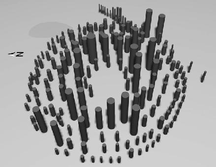
We could now see the Southern Circle’s full plan. It was remarkably similar to that of Stonehenge itself. The second innermost post “ring” was actually a horseshoe of uprights, just like Stonehenge’s arrangement of trilithons. It faced in the opposite direction to the Stonehenge trilithons,
however, toward the southwest and the midwinter sunset. The fourth circle of timber posts was equivalent in its position to Stonehenge’s sarsen circle, and had the same number of uprights—thirty in all. The two structures were built virtually from the same blueprint, one in wood and the other in stone, except that the horseshoe-shaped arrangement within each faced in exactly opposite directions.
Geoff’s finds have been curated by Salisbury Museum, so it was possible to obtain new radiocarbon dates for antler picks found in some of the Southern Circle’s postholes. Although we knew that the main structure (Phase 2) had been put up shortly after 2500 BC, there was no dating for Phase 1. Colin had also pointed out that some of the postholes assigned to Phase 2 were actually earlier, because their holes and construction ramps were cut by other postholes. He also suspected that the innermost ring had been erected after all the others because the ramps for these postholes sloped from inside to outside whereas all the other rings’ ramps sloped from outside to inside.
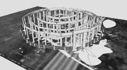
A computer-generated image of the Southern Circle in its final phase. The image has been created as an overlay on the excavation plan of the postholes and other features. The lintels are hypothetical.
The new dates from the museum’s antler picks suggested that there were probably more than two phases of construction. The southeast
façade of small posts, previously assigned to Phase 1, was no different in date from the timbers of Phase 2. As Colin had predicted, the innermost ring of posts, dating to 2580–2340 BC, could have been contemporary with Phase 2a, but was most probably put up after all the others. Two postholes—numbered 84 and 85—were probably put up slightly earlier than the others. Posthole 84 had been dug into by the holes of other large posts and so was earlier by perhaps a few years or decades. Together with posthole 85, it might have held one of a pair of timber uprights that framed the midwinter sunrise, possibly topped by a wooden lintel to form a timber trilithon (or, more correctly, a tridendron).
There was an even earlier setting of postholes, which were cut by postholes 84 and 85. These early postholes formed part of a circle, about 20 meters in diameter, of smaller posts just 20 centimeters wide. No antler picks were found in them so they cannot be dated.
We can now expand on Geoff’s observation that the Southern Circle was rebuilt more than once. It began with a square setting of posts at the center of two concentric circles of small posts, probably around 2500 BC (Phase 1). Probably about twenty years later, after the small posts had decayed, the builders put up a pair of large timbers to create a portal facing the midwinter sunrise (Phase 1/2). The main array of a horseshoe of timbers inside three concentric rings of timbers was then erected soon after, in the period 2485–2455 BC (Phase 2). Finally, a ring of small posts was constructed at the center of the circle in the period 2580–2340 BC, together with a ring of posts around the outside of the circle (Phase 2a). In all, there were probably four phases of construction, spanning a period of less than a century. The pits that were later cut into decayed posts continued to be filled for another 500–600 years.
Had Durrington Walls’ Southern Circle been built of stone, it would be recognized today as being just as architecturally magnificent and complex as Stonehenge itself. The fact that it was built of timber is, however, of great importance for unraveling the Stonehenge story. It now looks as if the Southern Circle and Stonehenge were very similar monuments, albeit in different materials.
__________
The results of the 2005 excavations were spectacular, revealing that Durrington Walls had once been a huge settlement of 42 acres, filled with small, square houses whose surroundings were clogged with Neolithic trash from feasts that must have involved thousands of people. Its central area was dominated by two timber circles (the Southern Circle and the Northern Circle, found in 1967). In 2006 we discovered that this central area was surrounded by a wide arc of impressive buildings, consisting of fenced-off houses. Later on, the entire settlement was enclosed by a huge, circular bank and ditch—the walls of the site’s name—which buried many houses around the settlement’s perimeter under deep deposits of chalk. Although thousands had lived here, this was never a town. It lasted decades and not centuries, and most of its inhabitants were probably seasonal visitors and not permanent residents.
With the discovery of the avenue and the unique Neolithic houses, we had verified part of the original theory about Durrington Walls being a place for the living, in a landscape of complementary monuments where wood and stone, the living and the dead, all played a part. We were in a good position to apply for a large grant and by 2006 the project had been awarded nearly £500,000 from the Arts and Humanities Research Council. Although most of this was for salaries and university overheads, it gave us enough to do the unglamorous behind-the-scenes lab work and analysis that are the principal aspects of archaeology.
For every month of digging in the field we were creating about six months of what is called “post-excavation”: the sorting and analysis of
finds and samples, the processing of digital data, the production of computerized plans and records, the drawing of finds, and the writing of detailed reports by an army of specialists. We needed experts to work on flint tools, animal bones, human bones, pollen, carbonized plant remains, wood charcoal, pottery, soil chemistry and micromorphology, land snails, and chemical isotopes in animals and humans.
The project was now on a firm financial footing and we could plan ahead. Rather than restrict our efforts to Durrington Walls, we could also investigate crucial sites at and around Stonehenge itself. We proposed another four years’ work, at Durrington Walls and Woodhenge, at the Stonehenge Cursus, along the ridge along the riverside south of Woodhenge, and at the Cuckoo Stone (a fallen standing stone near Woodhenge), then Stonehenge itself, its avenue and environs, with a final season to wrap up any loose ends. Our money worries were never quite over, though. Since most of the grant was earmarked to pay for post-excavation and compulsory university overheads, there was still not enough money to fund the digging. We were going to have to apply for extra grants every year, but the project was no longer “too speculative,” and even international organizations, such as the National Geographic Society, were excited by our discoveries.
In December 2005, we presented the project’s first results to a packed audience at the Theoretical Archaeology Conference in Sheffield. Working from old finds and records, we had a new argument about the dating of Stonehenge (about which more later) and had also taken stock of our own discoveries the previous summer. By studying photographs of the flint surface found in 1967 outside the southeast entrance to the Southern Circle, we could see that this was part of the flint-surfaced avenue that we had unearthed less than 100 meters away. The surface of broken flints had been laid at the same time as or after the Circle’s Phase 2 posts were erected. It had initially been interpreted as being a platform on which to make offerings and perform rituals, but was actually the western end of the avenue leading to the Avon.
We were less certain about the other end of the avenue. Erosion had destroyed the avenue nearer the river and the riverbank itself has moved during the last four thousand years, as the river has cut into the solid chalk on its west bank. If there ever was a timber or stone monument at
the riverside end of the Durrington Walls Avenue, it would have been eroded away long ago.
In 2006, we split the team into four different excavations. I stayed with the houses and avenue at Durrington Walls, Julian dug in the center of the Durrington Walls henge, Colin went two miles away to the northwest of Stonehenge next to Fargo plantation, and Josh dug two trenches into Woodhenge. One of these Woodhenge trenches was on the external bank enclosing the timber circle; the Neolithic ground surface would be preserved here and we hoped to find evidence of activities from before Woodhenge was built. The other trench was within an area already dug by Mrs. Cunnington. At the southern end of the timber circle her workmen had found two holes much shallower than the many postholes. She interpreted them as holes for standing stones, partly because some sarsen chippings were found close by. Josh wanted to know whether she was right and, if so, how the stones had related to the timber posts.