Read Stonehenge a New Understanding Online
Authors: Mike Parker Pearson
Tags: #Social Science, #Archaeology
Stonehenge a New Understanding (34 page)

A little later, this eastern avenue ditch was located in the other trench nearer the river, lining up with the spot further north where George Smith had last seen it in 1972. Yet it did not extend as far as the trench further south, inside the henge. Somewhere under our pile of shoveled earth, within a space of less than 10 meters, the avenue ended. The henge had once had an external bank, now entirely flattened, and the avenue ditch must have reached to the outer edge of this bank, or nearly so. We realized how lucky we’d been the year before with the positioning of our trench. Had it been two meters to the north, we would have missed both henge and avenue; even further north and we might have found the ends of the east and west ditches of the avenue but wouldn’t have had a clue that there was a henge in the vicinity.
In the trench where Denise found the arrowhead, the western avenue ditch took longer to find than the eastern ditch. It proved to be under the bank of a Medieval tenement boundary; presumably it had survived as a visible feature that was incorporated into the twelfth-century land boundaries as a useful line of demarcation between two properties. The avenue here at its riverside end is 18 meters wide, just a couple of meters narrower than it is nearer Stonehenge. Both ditches had contained rows of small posts.
We could see that there was a complicated sequence inside the henge. A Medieval drainage ditch had cut through a small, circular Bronze Age ditch at the henge’s center. This Bronze Age ditch was part of an arrangement that included postholes of various sizes, and all of these were cut into an earlier circle of interlinked holes. As the excavation progressed, we found nine of these earlier holes, six in the main trench and three others in the western trench, forming a curving or circular cutting. Each had its own ramp leading into it from the outside of the circle.
Gradually it dawned on us that these pits once held standing stones. The ramps enabled the builders to lower each stone into position, and the later removal of each stone left a V-shaped void, filled in with later material, where each stone had been pulled out from its packing of flint nodules and chalk. The antler pick that Josh had found right at the beginning of the excavation was lying on one of the ramps.
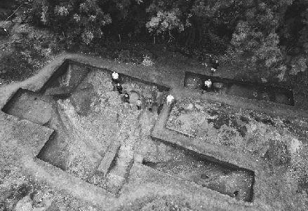
Diggers stand in the holes where standing stones once stood at Bluestonehenge, on the bank of the River Avon at West Amesbury.
The traces left by these upright stones were very different from those left by the narrower and deeper Bronze Age posts that came after them. And the holes themselves were wider and shallower than any of the holes for Neolithic posts at nearby Woodhenge and Durrington Walls. From the shape and size of the holes, we know that the stones they once held could not have been slab-shaped sarsens.
The standing stones had been placed on individually tailored cushions of river clay and pads of packed flint nodules. Each pit base was different, suggesting that the cooperative activity of erecting a stone circle had been carried out by separate teams responsible for each stone. One stone had sat on a carefully constructed nest of nodules, while others merely had a thin cushion of clay between their bases and the chalk. Another sat on a rock-solid pad of nodules and rammed clay.
The bottoms of five of the holes contained imprints of their stones, pressed through the clay cushions into the soft chalk beneath. The profiles (the cross-section shape) of the holes had already indicated that they’d contained neither posts nor sarsens. It now became clear from the
imprints in their bases that these holes had once held stones whose pillar-like shapes closely match the Stonehenge bluestones, with their variously curved, indented, and straight edges. We had to think of a name for this unknown site, and called it Bluestonehenge. Extrapolating from the curvature of the nine excavated stoneholes, we calculated that, if the stone arrangement continued to form a circle, it had consisted of twenty-five monoliths.
Radiocarbon dates from antler picks told us when the stones were removed from the stoneholes. Josh’s first find, the pick from the ramp, produced a radiocarbon date of 2469–2286 BC. A second antler pick, found right at the bottom of one of the stoneholes, dated to 2460–2270 BC. The stones had been extracted during the Copper Age, around the same time as the henge ditch was dug, and at the same time as the Stonehenge Avenue ditches were dug.
Working out when this bluestone circle was first erected is a more difficult question. No antler picks were deposited in the stoneholes when the circle was built. This absence of picks at Bluestonehenge mirrors their absence in other bluestoneholes—no picks have ever been found in any of the Aubrey Holes or the Q and R Holes at Stonehenge and there are only two antler fragments from the bluestone circle and oval. Archaeologists all accept that the depositing of antler picks in pits, stoneholes, and ditches was done with deliberation by Neolithic builders, and was not the accidental abandonment of perfectly serviceable building tools; it looks as if it just wasn’t the practice to leave such objects in these holes for bluestones.
We did initially hope that the pick found at the bottom of a stonehole had been put there when the stones were put up, because it seemed to be sticking out of the packing layer, but we later realized it had been stuck
into
that primary layer. Even without radiocarbon dates, however, the circle’s construction can be broadly dated by two objects: Chisel arrowheads were found in the packing of two of the stoneholes. Such arrowheads date to before 2600 BC, and they first appeared around 3400 BC. They’d therefore already gone out of use by the time of the village of Durrington Walls, so we hadn’t seen this type of arrowhead during our excavations there in previous years, but Colin Richards had found one in a pit by the Cuckoo Stone, dating to 2900 BC.
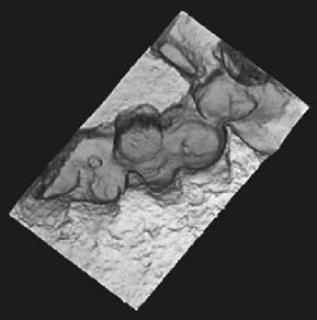
A laser scan of the Bluestonehenge stoneholes. Laser scanning is used to record objects and features in three dimensions.
One of the things puzzling me was why we had no chippings from the stones themselves, either from dressing them or from breaking them up on removal. The areas of high resistance on the geophysics plot weren’t caused by spreads of stone debris, but turned out to be concentrations of natural flint nodules; the circle of stoneholes was completely invisible to geophysics.
Going back to the numbers of bluestones and numbers of bluestoneholes at Stonehenge, I realized that Stonehenge seems to have taken delivery of a second batch of bluestones at some point. We know that the final circular and oval arrangement within the sarsen circle required about eighty bluestones. Fifty-six of these would have come from their first arrangement in the Aubrey Holes. Someone must have brought an extra twenty-four or so stones to the site to make up the numbers.
The similarity of the dates for dismantling Bluestonehenge and for digging the henge ditch at West Amesbury made me realize that the stones had probably been moved before the ditch was dug. There is a sound practical reason why this was so—the restricted access in and out
of the henge after the ditch was dug would have made it awkward to move the stones. Once the ditch was in place, the henge was accessible only by a causeway across the ditch on its east side. Our trench did not extend quite as far as the causeway, but we can see that the causeway existed because the henge ditch narrows on its east side to form a terminal.
Archaeologists always expect prehistoric ditch ends, or terminals, to produce finds. A ditch terminal seems to have been an important place, where the builders deliberately left collections of various items at the bottom of the ditch. At Bluestonehenge, where the ditch heads toward its eastern terminal, we found a classic example of such a special deposit of placed artifacts, just as expected. The bottom of the ditch terminal was covered with a spread of finds—antler, stone, and bone tools probably for flint-knapping, an antler pick, and knapped flints.
As we reflected on just how the Copper Age engineers had managed to extract the stones from their pits, we noticed another reason why the henge ditch had to have been dug after the stone removal had taken place. Using antler picks, the demolition crew dug out just enough chalk packing from around eight of the stones to tilt them outward at an angle of about 20 degrees from vertical. We could deduce this angle from the crushing in the pits’ edges. The ninth stone, one of the stones on the west side, was an exception: Here the workers dug out most of the stone’s exterior packing and undermined its base. For the majority of the stones, though, they somehow pulled them out of the ground at this steep angle of 70 degrees from horizontal. Some form of equipment, such as a wooden A-frame, must have been needed, and having a newly dug ditch in the way would have caused difficulties.
Here was another example, like Durrington Walls and the two mini-henges inside it, in which the construction of a henge enclosure, with the bank outside the ditch, marked the end of whatever had gone on previously at the site. Henges, with their inward-facing earthworks, were built as memorials to something that had already happened rather than to signal what might still be to come. They are backward-looking and commemorative.
To have taken stones from this point on the bank of the Avon to Stonehenge on the chalk plain, the lay of the land suggests that at least the first stretch of the route would have followed the route now occupied
by the avenue. At this, its eastern end, the avenue runs along a narrow spur of chalk bedrock flanked by lower-lying areas of clay. For anyone trying to land on the riverbank, this chalk spur would have offered a perfect landing spot on solid, dry ground.
There has always been discussion about why the avenue takes such a roundabout and indirect path between its eastern end near the Avon and Stonehenge at its western end. It doesn’t cut across the landscape in the most direct line between the two points, but instead follows the gentlest contours. Perhaps this was the route taken by the bluestones from Bluestonehenge to Stonehenge. The avenue’s ditches and banks may memorialize such an event, constructed after it happened, turning a remembered route into a formalized avenue in the same way that henges and cursuses commemorate places and pathways.
The shortest route on foot from Bluestonehenge to Stonehenge climbs the valley that leads to Coneybury henge and then follows the dry valleys to Stonehenge, to approach either Stonehenge’s south entrance or its more grandiose northeast entrance. Coneybury henge, close to the Early Neolithic pit full of feasting debris known as the Coneybury anomaly, may be another example of a henge ditch constructed around an earlier installation. In this case, bones on the bottom of the ditch, including half a dog, date to around 2800–2600 BC, while bones from one of a group of pits inside the henge date to before 2900 BC.
4
This pit inside the henge at Coneybury was part of a setting of holes, possibly forming a four-post structure and its approach, like the three found by Josh south of Woodhenge. Julian Richards found evidence for uprights having been pulled out of two of these holes, but without further excavation there’s no way of knowing for sure whether these were wooden posts or standing stones.
The addition of Bluestonehenge to our map of Neolithic and Copper Age Wessex helps us understand old discoveries. It now seems likely that Coneybury henge occupied a stopping point at the top of the ridge, looking back toward the River Avon and forward to Stonehenge, for anyone taking the direct route between the two sites. Perhaps it was a staging point—a “station,” in the traditional sense of the word—from which celebrants got their first view of Stonehenge after leaving the river.
There have been other finds that show the importance of this ridge, which runs north from Coneybury and continues as far as the high ground immediately east of Stonehenge, known as King Barrow ridge. In 1967, the Vatchers found a small pit on King Barrow ridge’s west side, beside what is now the A303 main road.
5
Within this pit lay two peculiar carved chalk plaques, and an antler pick dating to 2900–2580 BC. Fragments of similar plaques have been found within the Neolithic and Copper Age village at Durrington Walls. The pit finds are earlier than the finds from the Durrington settlement, and are decorated with unusual and elaborately carved Grooved Ware-style designs. One has chevrons and criss-cross motifs bordered by horizontal lines and more chevrons. The other has rectilinear meanders bordered by dotted lines. The meaning and purpose of such carved chalk plaques is entirely unknown. Such objects are extremely quick and easy to make, and the raw material is ubiquitous throughout the region. Yet these decorated pieces of chalk are surprisingly rare; they must have had some special value that we can only guess at.