The Falsification of History: Our Distorted Reality (96 page)
Read The Falsification of History: Our Distorted Reality Online
Authors: John Hamer

“The United States government is planning to use ‘cover and deception’ and secret military operations to provoke murderous terrorist attacks on innocent people.
Let's say it again: Donald Rumsfeld, Dick Cheney, George W. Bush and the other members of the unelected regime in Washington plan to deliberately foment the murder of innocent people – your family, your friends, your lovers, you – in order to further their geopolitical ambitions”.
Chris Floyd ‘Darkness Renewed: Terror as a Tool of Empire’ 2009
So, in summary, I would make this plea to anyone who cannot see how fear and ‘terror’ is being used as a tool to subjugate the world and its gullible peoples… Please wake up and look beyond the mainstream news media.
Look a little deeper into both current and past events.
By doing so, you will help prevent your children and your children’s children from becoming the slaves and pawns of the super-rich, forever.
Weather and Geological Manipulation
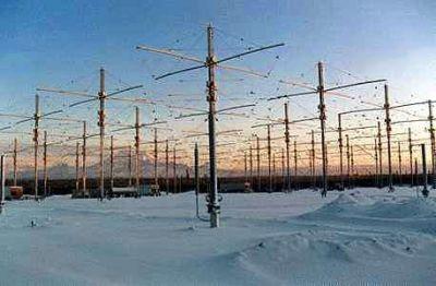
HAARP is possibly the most dangerous and sinister weapon known to man as well as being probably the least well known to the general public.
I would place it ahead of even the Atomic and Hydrogen bombs in this respect.
It consists of a huge installation of antennae, in Alaska USA and is the largest ionospheric heater in the world (see picture above) capable of heating a 1000 square kilometre area of the ionosphere to over 50,000 degrees.
It is also a phased array, meaning that it is steerable, despite widespread claims to the contrary by its apologists and its waves can be directed to a selected target area.
By transmitting radio frequency energy up into the skies above us and focusing, it causes the ionosphere to heat considerably.
This heating literally lifts the ionosphere within a 30 mile diameter area thereby changing localised pressure systems or perhaps the route of jet streams.
Moving a jet stream is in itself a phenomenal event.
The problem being that it is not possible to model the system accurately.
Long term consequences of atmospheric heating are unknown.
Changing weather in one place can have a devastating downstream effect and HAARP has already been accused of modifying weather for geopolitical as well as other possibly even more sinister functions.
Manipulating the weather and the environment for the purposes of US government sponsored terrorism is definitely not within the discussion remit of the mainstream news.
But it would appear that that is exactly what is happening.
HAARP is part of the weapons arsenal of the New World Order under the Strategic Defence Initiative (SDI).
From military command points in the US, entire national economies could potentially be destabilised through climatic manipulations.
More importantly, the latter can be implemented without the knowledge of the enemy, at minimal cost and without engaging military personnel and equipment as in a conventional war.
The use of HAARP, if it were to be applied, could have potentially devastating impacts on the World's climate.
HAARP is based in Alaska, where not only are we witnessing an increased incidence of earthquakes, but the prolonged eruption of volcanoes.
In 1958, then chief White House adviser on weather modification, Captain Howard T. Orville said that the US Defence Department was looking for ways to ‘manipulate the charges of the earth and sky and so affect the weather by using an electronic beam to ionize or de- ionize the atmosphere over a specific area.’
Recently, an ice bridge in the Antarctic collapsed and the Wilkins Ice Shelf could be on the brink of breaking away.
Is HAARP melting ice?
Is HAARP mapping weather patterns, agricultural seasons and crop cycles, or actually influencing them?
Responding to US economic, strategic and geo-political interests, it could easily be used and indeed has been used to selectively modify climate in different parts of the World resulting in the destabilisation of agricultural and ecological systems.
It is also worth noting that the US Department of Defence has allocated substantial resources to the development of intelligence and monitoring systems on weather changes.
NASA and the Department of Defence's National Imagery and Mapping Agency (NIMA) are working on ‘imagery for studies of flooding, erosion, land-slide hazards, earthquakes, ecological zones, weather forecasts, and climate change’ with data relayed from satellites.
On 26th December 2004, the Indian Ocean earthquake that generated the subsequent tsunami that killed over one quarter of a million people was unleashed on an unsuspecting world.
The magnitude of this earthquake was 9.3 on the Richter scale, making it one of the most deadly and destructive in all known history.
Wikipedia states that the earthquake itself lasted almost ten minutes when most major earthquakes last no more than a few seconds.
It caused the entire planet to vibrate several centimetres and it also triggered earthquakes elsewhere, even as far away as Alaska.
The section in Wikipedia, ‘Tectonic Plates’ provides more shocking pieces of information.
“Seismographic and acoustic data indicate that the first phase involved the formation of a rupture about . . . 250 miles . . . long and . . . 60 miles wide, located . . . 19 miles . . . beneath the sea bed - the longest known rupture ever known to have been caused by an earthquake.
As well as the sideways movement between the plates, the sea bed is estimated to have risen by several metres, displacing an estimated . . . 7 cubic miles . . . of water and triggering devastating tsunami waves.
The waves did not originate from a point source, as mistakenly depicted in some illustrations of their spread, but radiated outwards along the entire . . . 750 miles . . . length of the rupture.
This greatly increased the geographical area over which the waves were observed, reaching as far as Mexico, Chile and the Arctic.
The raising of the seabed significantly reduced the capacity of the Indian Ocean, producing a permanent rise in the global sea level by an estimated 0.1 mm.”
These facts are truly astounding.
There has obviously been a massive impact, including the raising of the seabed, causing the sea level worldwide to rise by 0.1 mm.
In the section entitled ‘Power of the earthquake’, there are even more disturbing statistics.
“The total energy released by the earthquake in the Indian Ocean . . . is equivalent to 100 gigatons of TNT, or about as much energy as is used in the United States in 6 months.
It is estimated to have resulted in an oscillation of the Earth's surface of about 20–30 cm (8 to 12 in), equivalent to the effect of the tidal forces caused by the Sun and Moon. The shock waves of the earthquake were felt across the planet; as far away as Oklahoma, vertical movements of 3 mm (0.12 in) were recorded. The entire Earth's surface is estimated to have moved vertically by up to 1 cm. . . . It also caused the Earth to minutely ‘wobble’ on its axis by up to 2.5 cm (1 in) . . . or perhaps by up to 5 or 6 cm (2.0 to 2.4 in).”
So, here is an event that expends so much energy it literally shortens the day, causes the earth to wobble and its surface to raise significantly.
Why would the Elite-controlled, US military-industrial complex want to turn the Indian Ocean area into a huge disaster area?
It seems inconceivable and pointlessly destructive – at first glance.
However, consider this; the Aceh area of Indonesia, the geographical location most badly hit by the earthquake/tsunami is known to be extremely rich in untapped oil resources.
Once this fact is understood it all becomes much clearer.
At this time, probably significantly, Aceh was in the grip of a devastating civil war, largely unreported in the Western, controlled media and seriously hampering the extraction and distribution of the oil reserves.
It would seem that on the morning of 26 December 2004, despite subsequent denials, the US authorities had foreknowledge of the earthquake (via the extensive early warning system in place) and the probable course of and the effects of the resulting tsunami.
As was the case on 9-11, the automatic warning system stood down, to allow a terrorist act to occur using the HAARP technology, to justify upcoming militarisation of the area with US troops in an area rich with oil.
Whether HAARP-induced or not, the critical issue would be the stand-down of the automatic earthquake warning system among its subscribing member nations.
This is at best criminal negligence and at worst a deliberate act of genocide for monetary and geopolitical gain.
The provable fact that an advance warning was given to Australia and the US military base in Indonesia only, demonstrates conclusively that there was criminal intent involved.
The third-world areas affected were left to suffer horrendously whilst oil-rich Aceh was invaded by over 2000 heavily armed US marines and two aircraft carriers equipped with dozens of ‘state of the art’ Cobra attack helicopters.
Strange also that the US military base in Indonesia also knew in advance about the planned attack / Tsunami.
The critical point of fore-knowledge, whilst not comprising conclusive proof of the use of HAARP technology, at least makes this possibility realistic.
We know that the technology has the capability to create the Asian tsunami so it is a fairly simple step of logic to deduce that the end-goal, ie. the US invasion of Aceh province would have justified the action in the twisted minds of those self-styled masters of the Universe.
Why would it be left to chance and the hope that a purely-by-chance incident of geological devastation would occur to facilitate a planned invasion?
“Others (terrorists) are engaging even in an eco-type of terrorism whereby they can alter the climate, set off earthquakes and volcanoes remotely through the use of electromagnetic waves... So there are plenty of ingenious minds out there that are at work finding ways in which they can wreak terror upon other nations... It's real, and that's the reason why we have to intensify our (counterterrorism) efforts.”
US Secretary of Defence, William Cohen, April 1997 at a ‘counter-terrorism conference’
Am I alone in finding the irony in this statement?
Cohen confirmed that there are in existence, electromagnetic weapons of this nature and there have been for many years, which have been and are being used to initiate earthquakes, engineer the weather and climate and also initiate the eruption of volcanoes.
Several nations now indeed have these weapons.
Following on shortly after the tsunami, on 28th March 2005, there was another earthquake in Northern Sumatra and Indonesia, measuring an almost equally gigantic 8.7 on the Richter scale, according to the National Earthquake Information Centre, US Geological Survey.
In addition, there were to be a total of six giant earthquakes around the World in 2005, all with a magnitude greater than 7.0.
Woods Hole Oceanographic Institution issued a news release entitled “Major Caribbean Earthquakes and Tsunamis a Real Risk — Events rare, but scientists call for public awareness, warning system.”
Paragraph 2 states that, “In a new study published December 24, 2004 in the Journal of Geophysical Research from the American Geophysical Union, geologists Uri ten Brink of the U.S. Geological Survey in Woods Hole and Jian Lin of the Woods Hole Oceanographic Institution (WHOI) report a heightened earthquake risk of the Septentrional fault zone, which cuts through the highly populated region of the Cibao Valley in the Dominican Republic.
In addition, they caution, the geologically active offshore Puerto Rico and Hispaniola trenches are capable of producing earthquakes of magnitude 7.5 and higher. The Indonesian earthquake on December 26, which generated a tsunami that killed (to date), an estimated 250,000 people, came from a fault of similar structure, but was a magnitude 9.0, much larger than the recorded quakes near the Puerto Rico Trench.”
There appeared to be a sudden spate of major earthquakes in 2005.
On 8th October 2005, yet another massive quake killed over 25,000 people and injured and displaced many thousands more in the Hindu Kush mountain region of southern Pakistan.
Estimates of the quake's magnitude varied from 6.8 to 7.8, with the United States Geological Survey putting the number at 7.6. Its epicentre was roughly 60 miles north of the Pakistani capital, Islamabad, where 20 ‘significant aftershocks’ measuring between 5 and 6.2 magnitude were felt throughout the day, said Dr. Qamar-uz-Zaman Chaudhry, director general of the Meteorological Department in Islamabad.