Read The Medieval English Landscape, 1000-1540 Online
Authors: Graeme J. White
The Medieval English Landscape, 1000-1540 (19 page)

The story of rural settlements from the early fourteenth century onwards is often told as a series of local reflections of national population decline: most contracting, some becoming deserted altogether, as disease and out-migration took their toll. Archaeological work at West Whelpington, for example, has shown the division of an area adjacent to the green into several new tofts in the expansionist thirteenth century, but the abandonment of the west end of the village and construction of a new boundary bank to delineate the reduced settlement thereafter. Yet in any specific case, the story is never as simple as it might seem. One reason for contraction at this site was almost certainly the impact of fourteenth-century Scottish raiding parties, as implied by the discovery of a cache of five silver coins apparently hidden in a drystone wall. And despite sometimes being labelled a ‘deserted medieval village’, West Whelpington did in fact survive the middle ages, only finally being abandoned about 1720. It was in good company in doing so, for several other now-abandoned medieval settlements – around 15 in Northamptonshire, for instance, perhaps six in Norfolk – continued beyond the sixteenth century, only later to fall victim to the landscaping of parks or other ‘improving’ initiatives.
80
Nuneham Courtenay (formerly Newnham, Oxfordshire), which some have argued is represented by ‘sweet Auburn’ in Oliver Goldsmith’s 1770 poem
The Deserted Village
after the residents had been removed nine years earlier, is one well-known example, although here again reality is complex: strictly speaking this was not a deserted settlement but a shifted one, since a replacement was built about 2.5 kilometres away along the Oxford to Henley turnpike road.
81
But whatever the circumstances in which settlements failed, their sites offer opportunities for study which still-occupied ones cannot. Their
earthworks can be recognized from the patterns of roughly rectangular tofts (surviving sometimes as house platforms, raised above their surroundings, sometimes as enclosing banks and ditches) with hollow ways (worn-down trackways) between them; very occasionally they bear evocative names such as Cold Newton (Leicestershire) – although this survives in much-shrunken form as a hamlet – and Hungry Bentley (Derbyshire) now represented only by Bentley Fields Farm (
Figure 13
). Also in Leicestershire, Whatborough, on a summit 230 metres above sea-level, has the distinction of being the subject of the earliest known plan of a deserted settlement, drawn up for All Souls College, Oxford in 1586 when its title to the large enclosure which had superseded the village and its fields faced a legal challenge; many of the features shown on the plan can still be recognized in the landscape today (
Figure 14
).
82
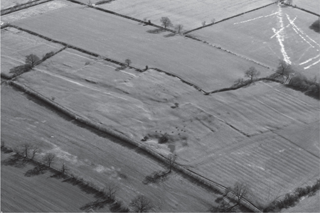
Figure 13: Hungry Bentley (Derbyshire)
. Earthworks characteristic of a deserted medieval settlement are clearly visible in a field of permanent pasture, including a pronounced hollow way – presumably the ‘main street’ – the roughly rectangular banks and ditches of former tofts (house-plots) alongside it and the ridge and furrow of medieval and later ploughing beyond. (©
webbaviation.co.uk
)
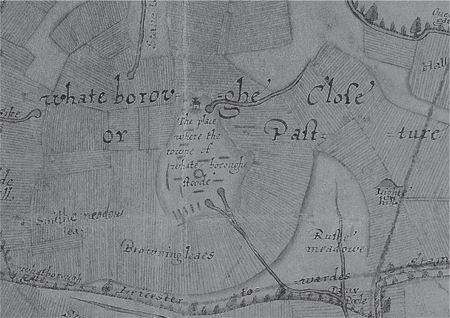
Figure 14: Plan of Whatborough (Leicestershire), 1586
. This plan, produced for an Elizabethan lawsuit, depicts the landscape of a deserted settlement (‘the place where the towne of whatebroughe stoode’) with enclosed pastures where there had previously been open arable fields. The ridges and furrows of former strips are indicated either by hatchings or by annotations. (Photograph from Hovenden Map I:19 by permission of The Warden and Fellows of All Souls College, Oxford.)
The phrase ‘deserted village’ is now used with caution, since it is acknowledged that depopulation was widespread in areas of dispersion as well as nucleation and that the majority of abandoned medieval settlements were in reality small hamlets and farmsteads. Cheshire and Essex, for example, are virtual blanks on the 1968 map of ‘Deserted Medieval Villages’ helpfully reproduced in the
Atlas of Rural Settlement
, yet the current Historic Environment Records show 93 ‘deserted settlements’ in the former county, 101 in the latter. Even within the ‘Central Province’, analysis of place names in the east midlands has shown that those with the element
thorp
or
throp
(generally indicative of an origin as a small, secondary settlement) were far more likely to be deserted than those featuring
ingaham
or
tun
, which tended to develop into parochial centres and to survive; further west in Warwickshire, it is known that 73% of places which ultimately became deserted were not the principal settlements within their parishes.
83
Among reasons for settlement desertion, the Black Death seems only occasionally to have been directly to blame. At Earnshill (Somerset) in 1352, the curate asked the bishop effectively to combine his duties with those at the neighbouring church of Curry Rivel because there was no one left on account of the recent pestilence. Similarly, at Tusmore (Oxfordshire), the lord was given permission in 1357 to ‘enclose his hamlet … and the highway … passing through it, the hamlet having been inhabited entirely by [his] bondmen but now void of inhabitants since their death in the pestilence’: but here numbers were already falling in the first half of the century, since it had arable land lying uncultivated in 1341, before the Black Death literally dealt a killer blow.
84
Other catastrophes – natural or man-made – were sometimes responsible, among them William the Conqueror’s creation of the New
Forest (an unusual example of afforestation having a direct, negative, impact on rural settlement), late-thirteenth-century inundations from the North Sea into Norfolk and Cambridgeshire, and fifteenth-century French raiding on the Sussex coast.
85
It is also clear that some places were deserted because of the deliberate actions of their lords. Osmerley (Worcestershire) and Budley (Somerset) fell victim to park creation in the early thirteenth century,
86
while in the 1180s Henry II’s courtier Walter Map castigated the Cistercian monks for clearing settlements either to create solitude for their abbeys or to replace them with granges worked by lay-brothers. Map had a personal grievance against this order and some of his language was certainly ‘over the top’, especially on the wider social consequences; in fairness it should be added, first that the Cistercians often made alternative arrangements for the displaced peasants and second that they were not the only religious order to act in this way. But his words would have rung true with some of those who read or heard them.
How gratefully do they enter upon lands that are given them … they proceed to raze villages, they overthrow churches, and turn out parishioners … Those upon whom comes an invasion of Cistercians may be sure that they are doomed to a lasting exile … they are left destitute … some are hooked into robbery or theft [and into] poverty which … defiles towns with thieves, arms forests with robbers, changes lambs to she-wolves, drives women from the marriage-bed to the brothel.
In reality, experiences differed from one place to another. At Accrington (Lancashire) in the 1190s, the monks of Kirkstall evicted the inhabitants to create a grange, the dispossessed promptly destroyed it and the monks then rebuilt it over again. Conversely, although the foundation of Rufford Abbey (Nottinghamshire) in 1147 led to the destruction of Rufford itself and also of neighbouring Cratley, all eight men of Rufford were given money in exchange for their lands and a new settlement, Wellow, grew up as a replacement.
87
It was similar action by lords in the late middle ages which caused particular outrage. Around 1490, the Warwickshire antiquary John Rous wrote in his
History of the Kings of England
that he had been petitioning successive parliaments since 1459 on the subject of ‘spoliators’ who ‘have ignominiously and violently driven out the inhabitants’ from villages and hamlets in his neighbourhood, listing 62 within a radius of 20 kilometres of Warwick which were ‘either destroyed or shrunken, which is to be deplored’. This behaviour was responsible for shortages and consequent high prices of grain, deaths from starvation, and (with echoes of Map) an increase in idleness, begging, and prostitution: even the security of the realm was under threat from a lack of available manpower.
88
About the same time, parliament legislated on the
subject, passing the ‘Act against the pulling down of towns’ in 1489, which railed against the ‘desolation and pulling down and wilful waste of houses and towns … and laying to pasture lands which customarily have been used in tilth’ and prohibited the demolition of any house to which 20 or more acres (at least 8.1 hectares) of arable had been attached within the past three years. Further legislation followed at intervals over the next half-century, with the
Domesday of Inclosures
of 1517–18 being the product of a government enquiry into offences committed. This tells us, for example, that in March 1489 (contrary to the Act of that year) the Prior of Bicester destroyed the five houses remaining at Wretchwick (Oxfordshire)
and lands formerly used for arable he turned over to pasture for animals, so that 18 people who used to work on that land and earn their living there and who dwelled in the houses have gone away to take to the roads in their misery and to seek their bread elsewhere and so are led into idleness.
Similarly at Wormleighton (Warwickshire) on 6 October 1498, the royal courtier and lord of the manor William Coope enclosed 12 tenements
with hedges and ditches on all sides, and those tenements still remain enclosed, and he willingly allowed those messuages and cottages aforesaid to be wasted fall into decay and ruin, and still they remain so. And he converted the aforesaid arable land … into pasture … whereby twelve ploughs which were fully engaged in cultivation of these lands are completely idle and sixty persons who lived in the aforesaid houses … were compelled tearfully to depart, to wander and be brought to idleness.
89
Thomas More’s satirical remarks in
Utopia
, eventually translated into English in 1556, illustrate the widespread understanding of the problem at the time, while also implying that more substantial settlements were liable to attract most attention, especially if they left churches as isolated features in the landscape (
Figure 15
).
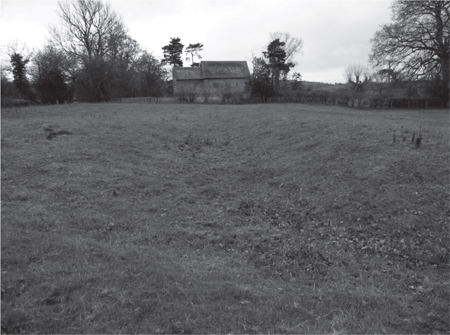
Figure 15: Heath Chapel and Deserted Settlement (Shropshire)
. The two-cell Norman church, which retains its early tiny windows and round-headed doorway, stands isolated apart from earthworks which include house platforms and hollow ways. Seven families were taxed here in 1327 and there was still some occupation in the late eighteenth century.
Sheep that were wont to be so meek and tame and so small eaters … be become so great devourers … that they eat up and swallow down the very men themselves … devour whole fields, houses and cities, tempting nobles and gentlemen and even abbots to throw down houses … and leave nothing standing, but only the church to be made into a sheephouse.
90