Read The Medieval English Landscape, 1000-1540 Online
Authors: Graeme J. White
The Medieval English Landscape, 1000-1540 (25 page)

If we are seeking genuine ‘new towns’, as opposed to extensions of, or replacements for, existing settlements, we need to look for speculative ventures at some distance from other communities, often located at the boundary between different jurisdictions and sometimes bearing a name which has the hallmarks of having been deliberately imposed. These can still be seen as ‘enterprise zones’, with incentives being offered to those prepared to move in and build on the plots made available, but at least the new settlement had an identity which clearly set it apart. In this group we can certainly include Battle (Sussex), which would not exist had William the Conqueror not founded an abbey on the site of his victory over Harold Godwinson in 1066, and the monks not proceeded to develop a town outside their main gate following the grant by the king of a Sunday market in 1070–71. A similarly speculative venture was Devizes (Wiltshire), founded by the Bishop of Salisbury probably in the 1130s to attract trade in the vicinity of his castle, named the
burgus de divisis
because it straddled two episcopal manors. So was Baldock (Hertfordshire), established by the Knights Templar (who named
it after Baghdad) in the mid-twelfth century at an important crossing on the Great North Road on the edge of two parishes. Mountsorrel (Leicestershire), a castle town probably of the mid-twelfth century located where two parishes met, and Brigg (Lincolnshire), named from a bridge which by 1235 had been built across the River Ancholme at the junction of four parishes, appear to be other examples of this type. The crown was not, of course, to be left out of the picture. About 1119 Henry I issued a charter encouraging settlement at the intersection in Bedfordshire of Watling Street and the Icknield Way, where he had a lodge called Kingsbury, promising burgage tenure and the liberties and privileges of the city of London; a weekly market and annual fair are mentioned here by the end of the reign. The place probably took its name, Dunstable, from a
stapol
or post which stood at the crossroads to point out the four ways.
54
Royal initiatives of this sort were especially important along the coast, although here again some foundations were really replacements for earlier towns no longer viable because of the vagaries of the sea: such as New Romney (Kent) already in existence by the end of the tenth century, and the Sussex towns of New Shoreham (founded by Philip de Braose about 1100) and New Winchelsea (founded by King Edward I in the 1280s), all of which replaced ‘Old’ versions with the same name which could no longer function effectively.
More convincing as ‘new’ were sea-ports given the names of local features, like Portsmouth at the entrance to the Wallington estuary where there was already a harbour at Portchester further upstream, and Liverpool at a tidal creek in the Mersey known as
le pool
; Richard I’s foundation charter for Portsmouth in 1194 granted burgage tenure with the privileges of Winchester and Oxford, adding a market and fair, while Liverpool received a foundation charter from John in 1207 which promised privileges to those who took up burgage plots ‘as any free borough on the sea coast of England then enjoyed’. Edward III took an alternative approach by honouring his wife when founding Queenborough on the Isle of Sheppey (Kent) in 1368; conversely, his grandfather Edward I, developing a port at the point where the River Hull entered the Humber, had called it Kingston. At this point, however, a cautionary word should be entered, since Kingston upon Hull was not really new, but an extension of an already successful port called Wyke upon Hull, which the king had bought from the Cistercian abbey of Meaux in 1293. In this instance, it was the monastic foundation, rather than its royal successor, which was truly the ‘new town’. Liverpool is also thought to have been preceded by a small fishing and farming settlement, whose open fields it took over and extended.
55
How was all this expressed in the landscape? As we have seen, a key feature of any medieval town, whatever its origins, was a place to hold a market: sufficiently large to accommodate stallholders but with access-points
narrow enough to control entry and exit, so that stall-rents and tolls could be collected. Many market grants to existing settlements must have assumed that the residents and traders would find a suitable location for themselves, hence the initial appeal of churchyards, but – as we have seen – by the thirteenth century ecclesiastical pressure was requiring other solutions. An obvious location was at the intersections of routeways, and the triangular market places at Bampton (Oxfordshire), Taunton (Somerset) and Ashbourne may have arisen in this way, not necessarily through deliberate planning. Where the main thoroughfare broadens into an elongated cigar shape, as at Henley-in-Arden and at Chard (Somerset), this may also have been a gradual, unplanned, development, the outcome of steady pressure by stallholders to encroach on either side of the street. However, market places with a more obvious rectilinear shape have the appearance of being consciously planned, all the more so if – as at St Ives (Huntingdonshire), Chipping Sodbury (Gloucestershire) and New Thame (Oxfordshire) – the main thoroughfare has clearly been diverted to ensure that travellers passed that way. Drivers using the main A44 between Evesham and Oxford are still forced to snake through the broad medieval market places of Moreton in Marsh (Gloucestershire) and Chipping Norton (Oxfordshire), both deliberately laid out with burgage plots on either side some distance from the original settlement nuclei marked by parish churches, and in Moreton’s case by the significant name ‘Old Town’ (
Figure 19
). We can also be confident that the market place was part of an overall plan where it was located just outside the precincts of a castle or abbey – like those at Battle, Devizes, Ely and St Albans – or occupied one block, or
insula
, within a grid system of streets, as at Castleton (Derbyshire) and Salisbury (Wiltshire).
56
That said, the original shape of a market place could quickly be transformed by structures built within it: the Abbot of Bury St Edmunds, for example, was in dispute with his townsfolk in the 1190s over the erection of what appear to have been permanent shops and booths, causing ‘so many and great encroachments in the market place’.
57
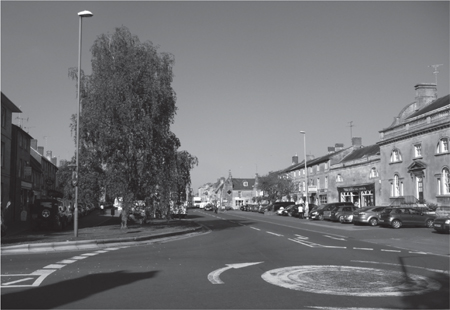
Figure 19: Moreton in Marsh, (Gloucestershire)
. Traffic on the A44 (bottom left) and A429 (bottom right) still passes through the wide market place laid out astride the Fosse Way, with burgage plots either side, in the early thirteenth century. The ‘Old Town’ with church is away to the right, secluded from this deliberately planned ‘burghal extension’.
This does not mean that all urban trade was restricted to the market place, since those who lived and worked within a town – as opposed to those who came in from outside – would frequent certain streets and quarters and carry out their businesses from there. William fitz Stephen’s description of London, dating to Henry II’s reign, explained that ‘those that ply their several trades, the vendors of each several thing, the hirers out of their several sorts of labour are found every morning each in their separate quarters and each engaged upon his own peculiar task’. This phenomenon, which has given many English towns their distinctive trade-related street names, persisted throughout the middle ages, whether because of some local amenity (like the riverside locations favoured by the dyers of Salisbury and Winchester) or because they were compulsorily excluded from the
town centre on the grounds of hygiene or fire risk.
58
The capacity to trade in these locations outside the principal market was facilitated by the fact that medieval streets were often fairly broad. When Stratford-upon-Avon was laid out at the end of the twelfth century it was to have streets at least 50 feet (15.2 metres) wide, while in 1480 William of Worcester on a visit to Bristol paced out several streets of 20 steps (about 10.7 metres) or more in width: one only 5 steps (about 2.7 metres) across was specifically named ‘Narrow St Thomas’s Street’. The impression sometimes given that medieval towns were a crowded network of narrow streets is false, being more characteristic of the sixteenth and seventeenth centuries, by which time street frontages had often crept forward. At Winchester, where the main thoroughfare was protected against encroachment but the side streets were not, the present-day High Street retains its eleventh-century breadth but streets leading off it funnel out: narrower towards the High Street where there was most advance from buildings either side, broader further away.
59
The layout of the streets within a medieval town was determined by factors such as local topography and the pattern of converging roads, but there was usually an element of deliberate planning at some stage. The most obvious signs of this are to be found in those ‘new towns’ established on supposedly virgin sites which displayed a rigorous grid pattern of streets.
New Winchelsea is often cited as a prime example (though even here there was a previous small settlement called Iham), partly because no less than 39 chequers can be identified from the original grid plan, and partly because surviving documentation allows us to tell the story of how Edward I, convinced that continued expenditure on the existing port of Winchelsea was a waste of money, acquired some 60 hectares on Iham hill and in 1281 commissioned a surveyor to ‘plan and give directions for streets and lanes, and assign places suitable for a market and for two churches’. On 25 July 1288 he duly transferred some 795 new house plots, arranged by streets and quarters, to the burgesses of the old town, though the initial promise that no rent would be collected for the first seven years seems not to have been honoured.
60
Similar stories doubtless lie behind other towns with grid plans, even if many of the details of their foundation are unknown.
There is a convention that in order to be classified as having a ‘grid plan’, a town must have at least three streets of equal importance running in each direction, and at least nine chequers or
insulae
. By these criteria, just over 20 medieval ‘new towns’ in England (including three in the Isle of Wight) exhibited the form, ranging in date from New Romney (Kent) by 960 to New Winchelsea as the last of the type. But failure to achieve nine chequers does not in itself mean an absence of planning. Plenty of urban foundations display some evidence of a grid and although these are not on the scale of three streets by three a deliberate overall plan seems more plausible than an assumption that the pattern arose as a result of piecemeal expansion. Both Bishop’s Castle (Shropshire), where the Bishop of Hereford founded the town in 1127 (
Figure 20
) and Hartlepool, where a pre-Conquest town was re-founded by the Brus family about 1180 as a port for the nearby settlement of Hart, had simple grids based on a principal street, one or two back lanes and several cross streets.
61
Elsewhere, such minor grids with few chequers might form only part of what is known to have been the medieval town, suggesting an element of planning but not necessarily the foundation anew of the town as a whole. A limited criss-cross pattern of this type can be discerned outside the west gates of the abbeys of Bury St Edmunds and Peterborough, the former attributed to the years prior to the Domesday Survey, the latter to Stephen’s reign when the abbot is reported (in one translation) ‘to have changed the site of the town to a better position’.
62
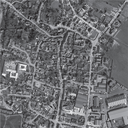
Figure 20: Bishop’s Castle (Shropshire)
. This twelfth-century planned town was laid out between the Bishop of Hereford’s castle to the north and a church (off-picture) to the south. Three roughly parallel streets run downhill from the castle – the central one broadening out to accommodate a market – with cross streets providing links between them. (© The GeoInformation Group.)
A tiny number of newly planted towns can be said to have had a ‘radial plan’, with streets fanning out from a dominant castle towards the surrounding defences: Richmond (Yorkshire), Pleshey (Essex) and Devizes, all dating to the twelfth century, conform to this pattern, although the precise arrangements differ.
63
By far the commonest plan, however, was that based on a single main street, usually accompanied by a market place either at one end or part way along it. This plan was also frequently encountered among nucleated villages,
so we find it where an existing settlement, like Higham Ferrers, was effectively granted urban status by its lord. It was also common where towns had been established along major routeways to take advantage of passing trade: witness the twelfth-century foundations of Uxbridge (Middlesex) where the London to Oxford road crossed the river Colne, described in Leland’s
Itinerary
as ‘but one longe streate’, and also Boroughbridge (Yorkshire) and Baldock, both on main roads from London to the north. Thirteenth-century examples include the Bishop of London’s Chelmsford (Essex), where the London to Colchester road crossed the River Chelmer, and Newmarket (founded by the Argentein family on the Suffolk-Cambridgeshire border). Several castle towns were also based around a single main street. Among these is Arundel (Sussex), apparently established between the Norman Conquest and the compilation of
Domesday Book; here, a main street runs down from the castle on the east to a river crossing and quay on the west, with a market place created where the street splays out near the bridge. Newcastle-upon-Tyne (a royal foundation sometime after 1080) and Pontefract (Yorkshire), a baronial new town which appears in Domesday Book, are other early castle-based towns, both with broad market streets running away from the castle gates. The late foundation of Queenborough in 1368 on ‘a broad and deep arm of the sea convenient for ships to put in at’ was constricted by its estuarine site to a simple main street between the castle and the sea.
64