Women of Intelligence: Winning the Second World War with Air Photos (38 page)
Read Women of Intelligence: Winning the Second World War with Air Photos Online
Authors: Christine Halsall

4
. Morgan (
née
Morrison), Suzie, recording.
5
. Scott, Hazel,
Peace and War
,
p.68.
6
. Morgan (
née
Morrison), Suzie, correspondence.
7
. Byrne, Paula,
Mad World
(Harper Press, 2009).
8
. Daniel, Glyn,
Some Small Harvest
, p.175.
9
. Horne (
née
Macalister), Elspeth, memoirs.
10
. Rendall (
née
McKnight-Kauffer), Ann, correspondence with Constance Babington Smith, 1956/7 (Medmenham Collection).
11
. Holiday, Eve, interview.
12
. Churchill, Sarah,
A Thread in the Tapestry
(Andre Deutsch, 1967), pp.57, 59, 65.
13
. Churchill, Sarah,
Keep on Dancing
, pp.67–76.
14
. Reid (
née
Ewen), Helena, script for audio recording for Medmenham Collection, 2001.
AY AND
D
OODLEBUGS
In the summer of 1942, Ursula Powys-Lybbe was detached from Medmenham to work at General Headquarters (GHQ) at Norfolk House in St James’ Square, London. This was the centre for planning Operation Torch, the code name for the invasion of North Africa in November 1942, and preparations for the future invasion of France, Operation Overlord. She was attached to the 21st Army Group and soon encountered several former Army Section colleagues from Medmenham. Ursula found herself the only officer wearing an air force blue uniform among all the brown army ones:
21st Army Group needed information about airfields and landing areas for the moment when the troops were to go in. I was asked to submit preliminary reports regarding the selection and suitability of certain specific areas for landing gliders and dropping parachute troops. The reports would then be passed to the geologists for their opinion on the terrain, and receive the final assessment from other experts.
1
Ursula’s work on landing areas for gliders and dropping zones for parachutists was just one small, but vital, part of the overall preparations for Overlord, which called for extensive intelligence input from all sources. One of the first orders to be implemented, more than two years before the invasion, was an increase in the number and frequency of photographic reconnaissance flights, with a corresponding increase in the volume of photographs being delivered to Medmenham. Tens of thousands of PR sorties were to criss-cross north-west Europe collecting information specific to the invasion, while the routine flights continued. Photography was one of the most efficient means of gathering intelligence for the planning of the largest amphibious invasion the world had ever known.
Since the fall of France and the failure of the German plan to invade Britain in 1940, both sides knew that at some point an Allied invasion of France would be launched, followed by an advance through the Low Countries and into Germany. By 1942 several major events made it possible to envisage and plan for a future invasion. The entry of the USA into the war against the Axis powers in December 1941, and their decision to prioritise the defeat of Germany before dealing with the Japanese domination in the Pacific, was crucial to any plans for a European invasion. The huge resources of US industry and manpower were essential for the planning and implementation of all Allied operations. The reverses inflicted on German forces following their invasion of Russia in 1941, had resulted in large numbers of troops being moved from Western Europe to reinforce the Eastern Front. The successful North African landings at the end of 1942, the first Allied operation, provided the springboard for a subsequent invasion of Italy and an advance northwards to the southern German territories.
The raid carried out on 19 August 1942 against the German-occupied port of Dieppe acted as a rehearsal for the future invasion of Normandy. It was designed to test the feasibility of capturing and holding an enemy-occupied port for some hours using combined ground, naval and air forces. In the event, none of the major objectives of the raid were achieved and accounts from prisoners revealed that the enemy had foreknowledge of the attack. While the Dieppe Raid provided valuable lessons in the planning of Overlord, it graphically illustrated how difficult the Allied invasion of Europe was going to be.
All Medmenham sections were involved in intensive long-term interpretation in the preparations for Overlord, but none more so than the Army Section. As a deterrent to invasion, the German forces had constructed a massive armed fortification, known as the ‘Atlantic Wall’, stretching along the north coast of France and the Low Countries. PR squadrons carried out repeated photographic sorties of a 30-mile-wide swathe of coast, from Holland to the French–Spanish border, providing information on the state of enemy defences that the invading Allied forces would have to overcome. Army PIs undertook the long-term task of examining all these photographs to locate and plot every existing gun installation and flak battery, updated with details of all enemy reinforcements. This was of vital importance for briefing air crews and indicating targets for Allied bombing raids. In addition, as described in Chapter 4, the PIs of the army sub-section, ‘B6’, including several WAAFs, located nearly 400 underground factories and depots constructed throughout mainland Europe from France to Czechoslovakia.
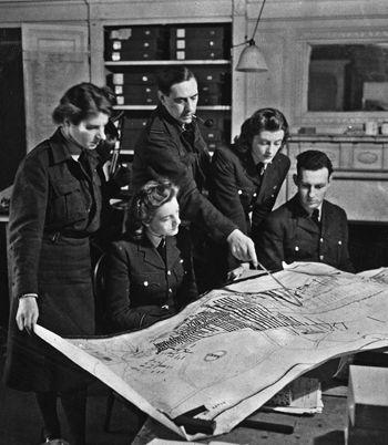
‘B6’ Army Section PIs examine the plan of the underground aircraft factory at Kahla, on the border of Czechoslovakia. Standing: Helga O’Brien (left), Geoffrey Orme and Sarah Churchill.
A key issue for the invasion was the selection of a suitable amphibious landing area. There were two possibilities: the Pas de Calais, which included the ports of Calais and Dieppe, or Normandy around Cherbourg. Photography was a prime source of information in the final choice of landing beaches and PIs examined the whole coastline of northern France, recording depths and tide levels at different times of the year, an enterprise in which even family photographs of children paddling at French holiday resorts before the war proved useful. The difficulty of moving tanks and tracked vehicles on pebbled terrain had been a major concern at Dieppe. For Overlord the expertise of several Medmenham PI geologists was called upon to examine samples of the Normandy terrain of sand and gravel, and to determine where beach landing craft could safely discharge heavy armoured vehicles. Dieppe had also shown the vital need to detect the beach and underwater obstructions that both landing craft and troops would encounter. Particular PI attention was paid to plotting these hindrances and traps in the form of stakes, spiked ‘hedgehogs’ and tripods, and also to the detection of the belts of mines buried in harbours and beaches.
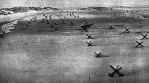
This low-level oblique photograph of defensive devices on a Normandy beach in 1944 reveals rows of stakes and ‘hedgehogs’, some mined, concreted into the beach. The two horses and dray were used for transportation on the sandy terrain.
The landing had to be of sufficient strength to set up a strong bridgehead before the enemy had time to react and bring up reinforcements. Normandy had no sizeable port equipped for oil-storage or discharge facilities and ensuring continuous fuel supplies was crucial. PLUTO – Pipe Line Under The Ocean – was the answer. Oil would be carried through a flexible hollow cable laid on the bed of the English Channel from Dungeness on the Kent coast and Shanklin on the Isle of Wight, to Normandy. This solution provides an example of the role of the Allied defensive camouflage detection that Joan Bohey was examining at Nuneham Park. The concrete mixers needed for construction work were located in the ruins of the Royal Spa Hotel in Shanklin, and every time a lorry came along the front, men were detailed to brush out the tyre marks in case enemy aircraft came over to take photographs. Further along the coast the pipeline was hidden from view in the shingle of Dungeness beach: ‘The effectiveness of this camouflage was tested each week by aerial photography, courtesy of the RAF, and no changes were ever visible.’
2
Two prefabricated military harbours were towed, in sections, across the Channel with the invading armies, and were assembled off the coast of Normandy. They were called Mulberries and provided all necessary port facilities, including piers and roadways. The American one was destroyed in a storm early on but the one at Arromanches, named Port Winston, which was built, operated and maintained by the Royal Engineers, saw heavy use for eight months, despite being designed for only three.
‘Bunny’ Grierson, carrying out First-Phase interpretation at RAF Benson, remembered D-Day and an early sight of these structures:
How did we, as a team of 15 or so UK and US interpreters, react to the news of the Second Front – at last? We all worked together at Ewelme, as necessity arose, very flexible, no-one having to explain their movements. In spite of watching the increases in enemy defence, the day by day, week by week, month by month, waiting had all became a background to me; until we started a lottery which went on for some weeks – ‘winner takes all’. I chose 9th June, my brother’s birthday, and won, being the nearest to the 6th!
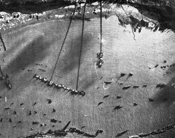
The Mulberry Harbour in place.
Shock – I heard it at breakfast in the Mess. There, and down at Ewelme later, I remember quiet, and hoping for news; as far as I remember that is all we were hoping for. Joy came, as I was lucky, I had no-one close likely to be part of the invasion force, at that time. Where was it? As we met up, any more news was shared. I wasn’t the only one feeling quiet, and any new news was shared, even what was heard on the radio; some with hope, some with fear. In spite of all this, still a sort of quietness. You saw people talking in groups, no secrets, anything new spread by word of mouth, eventually getting a wider picture by radio.
But we had film to work on, another sortie somewhere, I can’t remember. But I do remember the hope and purposeful determination to get on with our work.
Some time later, perhaps a day or two, we had some photographs which were sent straight to us to see. They were low obliques of platforms, at all angles along the edge of a long beach. There were various floating connections attached to the structure. The harbour became news later – it was called Mulberry.
3