Cadillac Desert (107 page)
Authors: Marc Reisner
Tags: #Technology & Engineering, #Environmental, #Water Supply, #History, #United States, #General


A section of the just-completed Los Angeles Aqueduct crosses the Mojave Desert.
(Photo Department of the Los Angeles Department of Water and Power)

Looking like a masterwork left by the Romans, Theodore Roosevelt Dam stands athwart the Salt River in Arizona. The Bureau of Reclamation’s first great structure- and the prototype of all high, curved-arch dams—Roosevelt Dam was constructed entirely of huge stone blocks hewn from cliffs in the Salt River Canyon.
(Bureau of Reclamation)

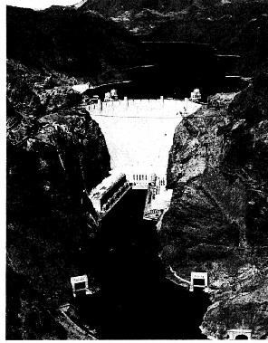
Still the architectural masterpiece among all the world’s dams. Hoover rises seventy stories from the bed of the Colorado River. Though Hoover appears minuscule compared to Lake Mead, whose length is greater than a hundred miles—it widens considerably a few miles upriver—the dam may outlast the reservoir.
(Bureau of Reclamation)

Grand Coulee Dam under construction in June of 1938. Appearances are deceptive: the width of the dam is four fifths of a mile.
(Bureau of Reclamation)

George Gillette, chairman of the Fort Berthold Indian Tribe Business Council, weeps as he watches Secretary of the Interior J. A. Krug sign a contract whereby the tribe sells 155,000 acres of its reservation’s best land in North Dakota to the government for the Garrison Dam and Reservoir Project on May 20, 1948. Gillette said of the sale: “The members of the Tribal Council sign the contract with heavy hearts.... Right now. the future does not look good to us.”
(AP-Wide World Photos)
For more than fifty years, the tiny man-made river in the foreground, the Granite Reef Aqueduct of the Central Arizona Project, has been viewed by Arizonans as the one thing that can save them from oblivion. In the next century, however, as seven states suck up their full share of the feckless and overappropriated Colorado River, the aqueduct may run as empty as the diversion canal on the right.
(Bureau of Reclamation)


Teton Dam, just as the flood abated. Hours earlier, the flow of four Mississippi Rivers was thundering through the breach. The big concrete structure on the left is the spillway, whose outlet works hadn’t been completed and which couldn’t be used to begin emptying the reservoir when the first signs of trouble appeared. The height from river level to the crest of the remnant of the dam is about thirty stories; at the spot from which the photo was taken, boiling waves were more than one hundred feet high.
(Bureau of Reclamation)
The remains of Teton Dam, as seen from the air, hours after the flood.
(Bureau of Reclamation)


The three main antagonists in the Narrows Dam controversy. To Colorado Governor Richard Lamm (AT LEFT) the dam was an offer he couldn’t refuse. To water lawyer Glenn Saunders (BELOW, LEFT) the dam symbolized a spendthrift society clinging to obsolete hopes. Former Colorado State Engineer C. J. Kuiper (BELOW, RIGHT) still believes the dam could fail catastrophically, as Teton did

A section of the spillway at Glen Canyon Dam completely destroyed by raging floodwaters spilled during the very wet EI Niño winter of 1982—83. Although the Glen Canyon spillways run directly beneath the dam through rock that is mainly sandstone, the Bureau of Reclamation insists that the structure itself was never threatened.
(Bureau of Reclamation)
OPPOSITE, ABOVE: The desert blooms on the Gila Project near Yuma, Arizona. Not far from here the Hohokam, one of the world’s great irrigated civilizations, went extinct.
(Bureau of Reclamation)
OPPOSITE. BELOW: The Control Room of the California Water Project, where the man-made now of nearly a trillion gallons a year is orchestrated.
(© Peter Menzel, 1986)
