Forbidden History: Prehistoric Technologies, Extraterrestrial Intervention, and the Suppressed Origins of Civilization (23 page)
Authors: J. Douglas Kenyon
Tags: #Non-Fiction, #Gnostic Dementia, #Fringe Science, #Alternative History, #Amazon.com, #Retail, #Archaeology, #Ancient Aliens, #History

“One of the common mistakes,” says Flem-Ath, “is to think of the continents and the oceans as being separate, but really the fact that there’s water on certain parts of the plates is irrelevant. What we have in plate tectonics are a series of plates that are moving very gradually in relationship to each other. But what we have in Earth crust displacement is that all of the plates are considered as one single unit, as part of the outer shell of the earth, which changes place relative to the interior of the earth.”
The theory, says Flem-Ath, offers elegant explanations for such phenomena as the rapid extinction of the mammoths in Siberia, the near universal presence of cataclysmic myths among primitive peoples, and many geographic and geological anomalies left unexplained by any other theory. Most of the evidence usually cited to support the idea of an ice age serves the theory of Earth crust displacement even better. Under the latter, some parts of the planet are always in an ice age; others are not. As lands change latitude, they move either into or out of an ice age. The same change that put western Antarctica in the ice box also quick-froze Siberia but thawed out much of North America.

Although many establishment geologists insist that the Antarctic ice cap is much older that the 11,600 years indicated by Plato, Flem-Ath points out that the core sampling on which most of the dating is based is taken from Greater Antarctica, which was indeed under ice, even during the time of Atlantis. The suggestion here is that a movement of about 30 degrees or about two thousand miles occurred within a relatively short span of time.
Before such a movement, the Palmer peninsula of Lesser Antarctica (the part closest to South America and whose sovereignty is presently disputed by Chile, Argentina, and Great Britain) would have projected an area the size of western Europe beyond the Antarctic circle into temperate latitudes reaching as far as Mediterranean-like climes. In the meantime, Greater Antarctica would have remained under ice in the Antarctic circle.
“An area such as that described by Plato,” says Flem-Ath, “would be the size of Pennsylvania, with a city comparable to modern-day London”—not a bad target for satellite photography. Concentric circles or other large geometric features should be easily discernible through the ice.
Flem-Ath believes that in most areas, Plato should be taken at his word, though he does suspect that there may have been some fabrications in the story. The war between the Atlanteans and the Greeks, for example, he believes may have been cooked up to please the local audience. In regard to the scale of Atlantean achievement, however, he takes Plato quite seriously and is very impressed. “The engineering feats described,” says Flem-Ath, “would have required incredible skill, more so than even what we have today.”
As for the notion that Plato’s numbers should be scaled down by a factor of ten—a frequent argument used to support claims that Atlantis was really the Minoan civilization in the Aegean—he doesn’t buy it. “A factor of ten error might be understandable when you are using Arabic numbers, with a difference between one hundred and one thousand of one decimal place, but in Egyptian numbering the difference between the two numbers is unmistakable.” For him the argument is similar to the one for a North Atlantic location, in which a modern concept has been inappropriately superimposed upon an ancient one.
So far Flem-Ath’s ideas have been largely ignored by the scientific establishment, but he believes that at least Hapgood’s arguments may be getting close to some kind of acceptance. “Quite often new ideas take about fifty years to be absorbed,” he says, “and we’re getting close to the time.”
If, in fact, satellite photography and seismic surveys produce the indications that Flem-Ath expects, what next? “The ice in the region that we are talking about is relatively shallow,” he says, “less than half a kilometer, and once we’ve pinpointed the area, it should be relatively easy to sink a shaft and find something.”
That “something” could be among the finest and most dramatic artifacts ever discovered—quick-frozen and stored undisturbed for almost 12,000 years. Is this a prospect hot enough to melt the hearts of even the most hardened skeptics? We shall see.
22
Blueprint from Atlantis
Doments of Ancient Monuments Have Something to Tell Us about the History of Earth’s Shifting Crust?
Rand Flem-Ath
I
n November 1993 I received a fax from John Anthony West that started me on a four-year quest. The article that slipped through the fax machine that day had been written by an Egyptian-born construction engineer by the name of Robert Bauval. Little did I suspect that Bauval would soon become known for his revolutionary theory that the pyramids of Egypt were a mirror image of the constellation of Orion. Bauval discusses this in his book, coauthored by Adrian Gilbert,
The Orion Mystery: Unlocking the Secrets of the Pyramids.
However, in the article I read that day, Robert Bauval had taken his idea even further. He revealed that not only the pyramids but also that most famous of all sculptures, the Sphinx, were oriented to the constellation of Orion as it appeared in 10,500
B.C.E.
This he discusses in another book, cowritten with Graham Hancock, entitled
The Message of the Sphinx: A Quest for the Hidden Legacy of Mankind.
John followed up his fax with a telephone call; this was to be one of our earliest conversations. He had read the original manuscript of our book
When the Sky Fell: In Search of Atlantis
and had volunteered to write an afterword. Our theory that Antarctica could hold the remains of Atlantis was framed by the concept of a geological phenomenon known as Earth crust displacement, about which I had spent years corresponding with Charles Hapgood.
I had concluded, based on extensive research into the origins of agriculture and the late Pleistocene extinctions, that 9600
B.C.E.
was the most probable date of the last displacement. After discussing details about the afterword for
When the Sky Fell,
John, in his usual direct manner, asked me: “If Bauval is right that the Sphinx points to a date of 10,500
B.C.E.
, how do you reconcile that date with your time period of 9600
B.C.E.
, for the last displacement of the earth’s crust?”
John had put his finger on a very important point. If the Sphinx had been built before the crustal displacement, as Bauval’s data indicated, then the monument’s orientation would have been changed as the earth’s crust shifted, resulting in a misalignment. But the fact remains that the Sphinx and, indeed, the whole Giza complex are precisely aligned with the earth’s cardinal points. “Either Bauval’s calculations of the astroarcheology are incorrect or your date of 9600
B.C.E.
is wrong,” John said. “How sure are you of that date? Could you be wrong by nine hundred years?”
“John,” I replied, “a host of archeological and geological radiocarbon dates indicate unequivocally that the last catastrophe occurred in 9600
B.C.E.
I’m sticking with that. Perhaps the ancient Egyptians were memorializing an earlier date that was tremendously significant to them, not necessarily the date that the Sphinx was carved.”
In October 1996, Robert Bauval and I continued the friendly debate at a conference in Boulder, Colorado. I was convinced that the Sphinx was constructed immediately after 9600
B.C.E.
and I explained why. Imagine, I began, that an asteroid or giant comet hit the United States today, utterly destroying the continent and throwing the whole culture back to the most primitive of living conditions.
Then imagine that a team of scientists, perhaps safely under the ocean in a submarine, survived the cataclysm and decided to commemorate their nation and leave a message for the future by constructing a monument aligned to the heavens. What date would they choose to mark the memory of the United States of America? Would it be 1996, the year that their world ended? I don’t think so. I believe that they would orient their monument to 1776: the date that the nation was born. And in the same way, I think that although the Sphinx was created around 9600
B.C.E.
, it is oriented to 10,500
B.C.E.
because that date was significant to their culture.
Now, it happens that inconsistencies and puzzles in science are like oxygen to my blood! My entire philosophy of science is predicated on the motto that anomalies are gateways to discovery. I usually conduct my research in a methodical and painstaking (some might say obsessive) manner. However, over the past twenty years of investigating the problem of Atlantis and the earth’s shifting crust, I have discovered again and again that chance plays a critical role in discovery.
Between writing novels, my wife, Rose, works part time at the local university library, and her serendipitous approach to research ideally balances my own meticulous methods. I can’t begin to count the number of times that she has brought home a book that turned out to be exactly what I needed. So when she presented me with
Archaeoastronomy in Pre-Columbian America,
I eagerly flipped it open.
Written in 1975 by Dr. Anthony F. Aveni, one of the leading astroarcheologists in the world, the book dropped right into my lap a critical piece of the puzzle that I was trying to solve. It appears that almost all of the major megalithic monuments of Mesoamerica are oriented east of true north. Aveni wrote that the people of Mesoamerica did tend to lay out many of their cities oriented slightly east of true north. Fifty of the fifty-six sites examined east of north.
However, I found Aveni’s explanation for this alignment wanting. He believes that the Street of the Dead, the famous avenue at Teotihuacan (near Mexico City), is the key to the whole mystery of why the monuments are strangely misaligned. This street, which runs directly toward the Pyramid of the Moon, is misaligned fifteen and a half degrees east of north. Because it points within one degree to the Pleiades constellation (a set of stars important to Mesoamerican mythology), Aveni views this skewed alignment as a kind of template, a master plan, for the rest of the megaliths throughout Mesoamerica. While this is true for Teotihuacan’s Street of the Dead, it is not true for the other sites that Aveni lists in his book. His argument that the other forty-nine sites are merely inadequate copies of the holy alignment of Teotihuacan rang hollow.
I had a different idea, a theory based on the science of geodesy, which is the study of the measurement of the shape and the size of the earth. In addition to astronomical observatories, what if these Mesoamerican sites were part of a vast geographical survey? My study of ancient maps had convinced me that the Atlanteans had mapped the world. What if the orientations of the most ancient cities of Mexico were remnants of a lost science, the science of geography? What if the alignment of the ancient cities was a stone stencil, a precise blueprint of a prediluvian Earth?
Teotihuacan lies upon the longitude of 98:53 west. If we subtract the 15:28 degrees that it is misaligned, we get a location of 83:25 west, less than half a degree off Charles Hapgood’s location of the North Pole prior to 9600
B.C.E.
In other words, the Street of the Dead was fifteen and a half degrees west of the longitude that Hapgood had calibrated for the old pole.
When I made this discovery, I was naturally very excited. Could it be that the ancient monuments of Mexico were orientated to the pole before the last Earth crust displacement? The implications were profound. Such an orientation would point to the existence of a civilization that must have held scientific knowledge of the earth’s geography. They also must have possessed sophisticated surveying methods that they put to use in America before the earth’s crust shifted.
I soon discovered that several important Mesoamerican sites (Tula, Tenayucan, Copan, and Xochicalco, for instance) matched my geodetic theory. Each of their misalignments, when subtracted from their current longitude, yielded the longitude of the North Pole before the last Earth crust displacement (83 degree west). What if, I wondered, there were other sites in the Old World that were orientated to the old pole?
I began to research sites in Iraq, cradle of the most ancient civilizations. Unlike in Mesoamerica, these sites had not been studied in relation to their misalignment to the earth’s cardinal points. I had to piece together the evidence from site to site, from author to author. But the tedious task was worth the startling result obtained. I soon discovered that many of the oldest sites in the Middle East are west of today’s North Pole. Like the ancient sites of Mesoamerica, they were oriented to the old pole.
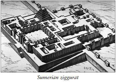
In the ancient city of Ur, its ziggurat (a stepped pyramid symbolizing a sacred mountain) and its shrine to the Moon god, Nanna, are oriented west of north (toward the old pole in the Hudson Bay).
Without control of the holy city of Nippur, no ruler could rightfully claim to be the king of Sumeria. The remains of the city lie south of Baghdad, where some of the most famous tablets in archeology were unearthed at the turn of the twentieth century. The tablets disclosed the Sumerian belief in the existence of a long-lost island paradise called Dilmun. The myth of Dilmun, which we show in
When the Sky Fell,
is remarkably similar to the mythology of the Haida people of British Columbia, and relates how the island paradise was destroyed by the god Enlil in a Great Flood. Enlil’s incredible power is honored at Nippur with a temple and a ziggurat that is skewed west of north. The ziggurat and White Temple of the Sumerian city of Uruk also point to Hudson Bay rather than true north.
The more I looked, the more ancient sites I found in the Middle East that pointed to the North Pole before the last Earth crust displacement. Perhaps the most poignant is Jerusalem’s Wailing Wall, the only remains of Herod’s Temple, built upon the site of Solomon’s Temple.
I now knew that I was looking at a unique geodesic phenomenon that demanded exploration. My next step was to calculate the former latitudes of the key megalithic and sacred sites of the world. If the latitudes were located at significant numbers, I could be sure that I was really on to something.
The first site I measured was, of course, the eternally compelling Great Pyramid at Giza. I calculated its coordinates against 60 degrees N 83 degrees W (Hudson Bay pole). Giza had been 4,524 nautical miles from the Hudson Bay pole, which meant its latitude was at 15 degrees north prior to 9600
B.C.E.
I found it odd that Giza, which today lies at 30 degrees north (one third of the distance from the equator to the pole), should have been so neatly at 15 degrees north (one sixth the distance) before the last Earth crust displacement. So I decided to study Lhasa, the religious center of Tibet, because I knew that this city, like Giza, lies at 30 degrees north today.
Lhasa’s coordinates are 29:41N 91:10E, which calculated at 5,427 nautical miles from the Hudson Bay pole. The distance from the equator to the pole is 5,400 nautical miles (90 degrees times 60 seconds = 5,400), so Lhasa had rested just twenty-seven nautical miles (less than half a degree) off the equator during the reign of Atlantis. This was getting spooky. The Earth crust displacement had shoved Giza from 15 degrees to 30 degrees while moving Lhasa from 0 degree to 30 degrees. Was this coincidence?
The coincidence started to become extreme when I compared the location of Giza and Lhasa (and a host of other ancient sites) with the position of the crust over three Earth crust displacements. I was amazed to discover that latitudes like 0 degree, 12 degrees, 15 degrees, 30 degrees, and 45 degrees came up again and again. Each of these numbers divides the earth’s geography by whole numbers.
This seemed way beyond chance, so I christened them “sacred latitudes.” Most of these sites will be familiar to anyone who takes an interest in archeology or the sacred sites of the world’s major religions. All of these places are within thirty nautical miles (a day’s walk) from sacred latitudes, and are thus more accurately aligned geodesically than Aveni’s astronomical calculations.
The careful reader will note that several of these sites show up in more than one table. They are actually situated at the crossing points of two (even three) sacred latitudes. For example, Giza lies at the intersection of 15 degrees (Hudson Bay pole) and 45 degrees north (Greenland Sea pole) and today is at 30 degrees north. Lhasa, which today is near 30 degrees north, was at the equator during the Hudson Bay pole and only thirty-two nautical miles from 30 degrees north during the Greenland Sea pole.