Authors: Codex Regius
Middle-earth seen by the barbarians: The complete collection including a previously unpublished essay (11 page)

- G
EOGRAPHY
During the Fading Years, the decaying Third Age, global mapping assumed a flavour of Ptolemy-ism, falling back on what had already been said before and centred on the ‘civilised’ lands of ‘the North’. ‘
The bounds of this region were naturally vague; its eastern frontier was roughly the River Carnen to its junction with Celduin (the River Running), and so to Nurnen, and thence south to the ancient confines of South Gondor. (It did not originally exclude Mordor, which was occupied by Sauron, although outside his original realms “in the East”, as a deliberate threat to the West and the Númenóreans.) “The North” thus includes all this great area: roughly West to East from the Gulf of Lune to Nurnen, and North and South from Carn Dum to the southern bounds of ancient Gondor between it and Near Harad
.’
(
TI
)
Near the edges of the maps sketched within those boundaries, available data rapidly petered out until they ceased entirely. Only a few, vaguely applied names of almost mythical quality show up. In Harad, south of Ithilien, ‘
there are more lands, they say, but the Yellow Face
[i. e. the sun]
is very hot there, and there are seldom any clouds, and the men are fierce and have dark faces
.’ (Gollum,
TT
) One of the most remarkable features, beside skin colour, seemed to be the
múmakil
, giant relatives of our elephants that left traces even in the poetry of Arnor and the Shire where they were called ‘
oliphaunts
’
(
ATB
)
.
In the eyes of the West, Rhún seemed to consist of ‘
wide uncharted lands, nameless plains, and forests unexplored
’
(
FR
)
- so much unexplored that mythmakers found a lot of space to fill: ‘
The wild white kine that were still to be found near the Sea of Rhún were said in legend to be descended from the Kine of Araw, the huntsman of the Valar, who alone of the Valar came often to Middle-earth in the Elder Days. Orome is the High-elven form of his name
.’
(
KR
)
Especially Steward Vorondil (2029-2080 TA) gained lasting reputation as “the hunter” by pursuing the ‘
wild kine of Araw in the far fields of Rhún
.’
(
RK
)
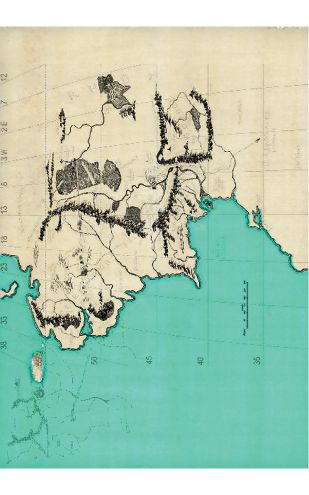
- Latitudes and longitudes on the LR map
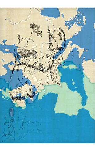
- North-western Middle-earth projected on the map of Europe
The mapped North (or West) obviously comprises only the smaller part of the landmass of Middle-earth, both by territory and by population. In the first millenium of the Third Age, the Men of the West were ‘
greatly outnumbered by those of the East and South
.’
(
TI
)
Harad was described as a land ‘
where the stars are strange
’
(
FR
,
TI
)
, signifying that it stretched, like the African continent, into the Southern hemisphere. How far Rhún extended into the east is not known because it cannot be told how profoundly the transition from a flat to a round earth in the late SA affected the landmass. It may, however, be possible to draw some indirect conclusions on the geographical area outside the West.
Twice, Tolkien confirmed that ‘
Hobbiton and Rivendell are taken … to be at about the latitude of Oxford
’, that is, at 51°45′N.
(
L
294,
PBD
)
Applying this statement to the original, ‘large Middle-earth map’ of
LR
reveals that the port of Umbar, the southernmost specified location of the charted lands, is located at 35°30’N. This corresponds more or less to the latitude of Tanger in Morocco and matches occasional comparisons of the Corsairs of Umbar with the corsairs of the medieval Mediterranean Sea
[1]
. If Tolkien’s argument may be extended to the assumption that Hobbiton was also near the longitude of Oxford, 1°15′W, then the charted territory of Middle-earth extends east to about the longitude of modern Kiev, 30°34’E.
Hence, it does not seem too bold to identify Near and Far Harad with early precursors of White and Black Africa while Rhún geographically corresponds to Eastern Europe and Asia.
Almost no information on their morphological structure has been recorded. The lands known from the Dawn of Ages had vanished long ago, ‘
and to
[Lake]
Cuivienen there is no returnin
g’.
(
S
)
The primordial Sea of Helcar was gone as well, perhaps it had ‘
vastly shrunken
’
(
QS
)
and may have been reduced to the later Sea of Rhún. The Orocarni, or Mountains of the East, that the Elves had seen were probably lost. Only Hildorien, where the fathers of Men came from,
(
S
)
seems to have been preserved in a way, though it was probably changed beyond recognition. Some sources claim that ‘
Men awoke in Mesopotamia
’,
(
DA
)
and this would place Hildorien far to the southeast, even beyond Mordor and Khand.
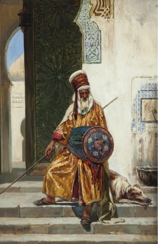
- A guardsman from Near Harad
Gondorian writers seem to have vaguely, and probably incorrectly, concluded that the plain grasslands prevalent to the south and east of the Sea of Rhún virtually extended into the infinite. One early draft of a map suggests that there may have been a desert east of Umbar. Beyond this doubtful information, no details of the geography of either Rhún or Harad are available. Save for one.
It is frequently overlooked that Sauron (and the Nazgûl) maintained a third fortress in Rhún which was never located and destroyed by Western forces.
Various sources explicitly state that Mordor was not the original domain of the Dark Lord after he had escaped from the fall of Angband, and that this country was only later ‘
occupied by Sauron, though outside his original realms “in the East”, as a deliberate threat against the West and the Númenóreans.
’
(
TI
)
That happened only after the first millenium SA. Another source adds that ‘
he surrounded his abode with fire
’,
(
RP
)
and this description cannot be reconciled with Barad-dûr, despite its proximity to Orodruin.
This third and eastern stronghold of the Dark Lord apparently continued to exist throughout the Third Age. For, when Dol Guldur is under attack in 2063 TA, ‘
Sauron retreats and hides in the East
’
(
TY
)
; and he stays there for almost 300 years before he returns to the West ‘
with increased strength
’
(
TY
)
. His refuge in the ‘East’ cannot be located in Mordor because the Land of Shadow was at that time closely under Gondor’s supervision. And at a place that provided to Sauron a base which lasted three centuries, he certainly had more profound business than just to wash his black feet in the Sea of Rhún.
[1]
For a detailed discussion of how to apply a meridional grid on the map of
LR
, see
“Appendix B Latitudes and longitudes of Middle-earth”
- C
ULTURAL FEATURES- The Swarthy Men
- The Swarthy Men
The tribes of men who latest immigrated into Beleriand became collectively known as Rhúnedain, Easterlings and Eastrons. The terms were geographically misleading because, of course, they all ultimately came from Hildorien, just like the ‘Western’ Edain. ‘East’ seems to have simply referred to those who had fallen behind on the long trail west.
Their physical characteristics gave them another epithet that distinguished First Age Rhúnedain from Dúnedain. They were also referred to as Swarthy Men, for they ‘
were short and broad, long and strong in the arm; their skins were swart or sallow, and their hair was as dark as their eyes. Their houses were many, and some had greater liking for the Dwarves of the mountains than for the Elves.
’
(
S
)
Note that by far not all of them were subjects of Morgoth! However, though some would adopt traces of Edainic culture, that was in turn influenced by the Noldor, the Swarthy Men never got really comfortable with the Edain.
Rhúnedainic women were described as strong as those of the Haladin, ‘
proud and barbaric
’. (
TG
) Like the Bëorians, they used to alliterate names of fathers and sons; some of them are strikingly similar to Bëorian counterparts: notably
Bór
. Others, like
Ulfang, Ulwarth
etc., seem to have been taken from a tongue that had a superficial similarity to Germanic or proto-Germanic. The Easterling name
Brodda
actually is a modern German surname. And there is another common denominator of Dúnedain and Rhúnedain tongues: both reveal distinct influences of Khûzdul because, also, ‘
of the tongues of the Easterlings many show kinship with Dwarf-speech rather than with the speeches of the Elves
.’
[1]
(
NE
)
Two distinct groups of Swarthy Men developed in Beleriand: On the one side were the followers of Bór, ‘
who were worthy folk and tillers of the earth
’
(
GA
)
, and on the other, those of Ulfang the Black who apparently were hunters and gatherers. Both groups had attracted many recruits before the Battle of Unnumbered Tears but it seems that few people of Bór, if any at all, survived this fight, for they are no longer mentioned afterwards. Ulfang and his sons were slain, but his kinsmen would rule Hithlum as vassals of Morgoth, and they did not learn about civilisation.